Note: I wrote most of this last spring for a previous incarnation of my blog, but am republishing here since my Facebook feed is full of cherry blossom photos now. We did this on April 6, 2017, so almost exactly a year ago.
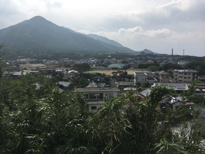
So Tokyo’s shitamachi(下町), literally “low city”, is a great place to cycle around because it’s a filled in swamp and very flat. Since it’s so flat, it’s not very difficult to get around on a mamachari, typical Japanese neighborhood grocery shopping bike which may or may not have more than one gear.
Last spring, after the snow season, I took some of the Schneider season staff who were staying at a backpackers near Asakusa on a cycle tour of the east side of Tokyo (otherwise they were stuck partying in neon-lit Shibuya).
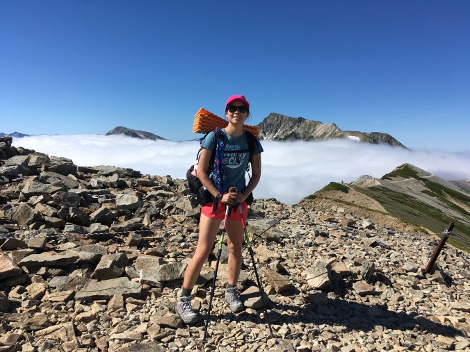
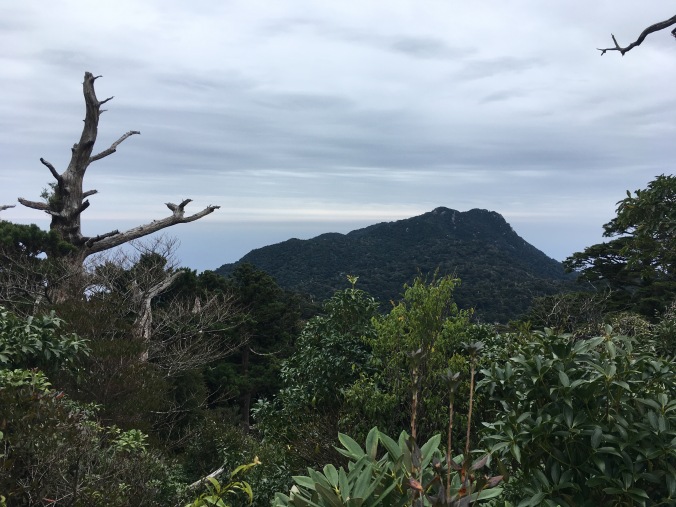
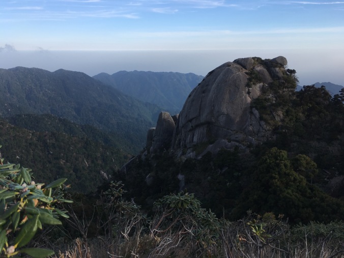
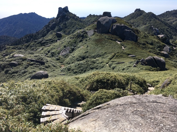
Cherry blossoms in full bloom along a canal near Fukagawa
Here’s the itinerary we took: Asakusa Station -> Kiyosumi Garden -> Tsukishima -> Tsukiji Market -> Kabukiza Theatre -> Imperial Palace -> Sumida River -> Asakusa Station
Taito City Rent-a-Cycle
Taito City, the municipality where Asakusa is located, rents mamachari type bicycles for 300 yen a day (return by 8PM) from four locations. The most convenient pick up point for us was the Sumida Park underground bike parking facility located right next to Asakusa Station and Azumabashi Bridge.
I called ahead the morning of to try to reserve 4 bikes for us, and was told I could not reserve but that we would have no problem renting 4 bikes after 12 noon (this is why we ended up starting our tour around 1PM). So I would recommend calling ahead for availability.
The number for the Sumida Park rental location is 03-3841-4031 (likely Japanese only).
There are numerous other options to rent bikes on the east side of Tokyo, but this public one is the cheapest.
You need to bring photo ID (passport or residence card for foreigners) and fill out the address of where you are staying to rent the bike. But it was a pretty smooth process and the bikes were of not bad quality. (I suspect this is where some of those abandoned mamachari’s at train stations that get fixed up by retirees in each municipality end up.)
There was a cool bike escalator to help you push the bike up the ramp out of the underground parking facility.
Bike escalator
Kiyosumi Garden
Kiyosumi Garden is a Meiji Era Japanese garden administered by the Tokyo Metropolitan Government. It’s designed so that you take a meandering walk around the pond, over bridges and stepping stones. The pond was full of koi, turtles, ducks and tons of tadpoles. There were also many beautiful birds stopping by. We were surprised by the amount of wildlife in the garden. Here’s the official website: http://teien.tokyo-park.or.jp/en/kiyosumi/index.html.
Please do not be an obnoxious gaijin and disturb the wildlife in Kiyosumi Garden
Tsukishima Monja Street
Completed in 1892, Tsukishima is the oldest landfill island in Tokyo Bay.
Enough high-minded tour-guiding. Actually, this entire cycling itinerary was born of my idea to take my friends down to Tsukishima for monjayaki lunch. Monja is my favorite food to haze visitors with, because it looks like vomit. But the ingredients are pretty benign and who doesn’t like to play with their food? I’m a nice person. I could be hazing visitors with shiokara (fermented squid pickled in it’s own guts).
There’s a covered shopping street on Tsukishima that is lined with monjayaki shops. Just pick a shop that looks busy but not too busy and walk in!
Monja Street
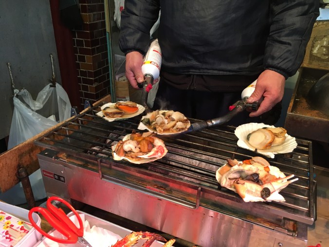
Tsukiji Market
I’ve never seen the tuna auction and waking up at 3 am to line up for Sushi Dai does not appeal to me, but the outer (retail) market is always fun to walk around. Everything closes down by 3 pm though, so not much was open when we passed through here on the bike tour.
A bit of afternoon snack
Kabukiza Theatre
Cycling straight down Harumi-dori from Tsukiji to Hibiya to get to the Imperial Palace, you will pass Kabukiza Theatre. The building is now kind of interesting from an architectural perspective because is was rebuilt in 2013 to have an abomination of a skyscraper coming right out of the top of it, kind of like Grand Central Station in New York.
Kabuki theatre is the Elizabethan theatre (e.g. Shakespeare) of Japan. It was born of entertainment for the masses, so there is witty banter, beautiful dancing, and exciting action scenes involving trap doors and other stage tricks. You don’t need to understand Japanese or know anything about the story (Kabuki plays tend to be in media res like Greek plays) to enjoy it. Traditionally kabuki was an all day affair where you would go and eat and drink and socialize all day (like Peiking Opera) and plays went on forever so people wouldn’t always be paying attention (like American baseball). Now, Kabuki performances are usually just a series of highlights from the most famous plays broken into matinee and evening sessions. If you want to see kabuki and have not planned in advance (the lower price tickets tend to sell out quick), you can try your luck to get a hitomakumi “one-act” ticket on the day of the performance.Tokyo Cheapo has a good article about how to do hitomakumi.
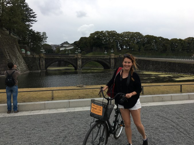
Imperial Palace
We passed near Nijibashi of the Imperial Palace. The Imperial Palace sits in the middle of Tokyo and since all train lines have to go around it, no train line in Tokyo seems to go straight east-west or north-south, making the Tokyo Metro map super intimidating. The palace is almost an exact 5KM loop making it a popular spot with runners.
No bikes allowed here. Police came to shoo us away.
Sumida River
Unfortunately, there doesn’t seem to be a good bike path along the Sumida River. There is a walking and jogging path, but bikes are not allowed. We cycled across the bridge near Asakusabashi, headed north a bit on the other side of the river and then crossed back over another bridge before taking some back streets back up to Asakusa and the Sumida Park bicycle parking facility. There is apparently a cycle path along the Arakawa that I would like to check out next time.
Obligatory golden poo and Sky Tree photo
Trip Data:
Total Cost: 300 yen bike rental + 150 yen entrance to Kiyosumi Park + 1700 yen monja lunch incl. one beer = 2150 yen per person
Distance: ~10 km
Time: 5 hours (including signing up for and returning the rental bikes, fully enjoying the wildlife in Kiyosumi Garden, two rounds of monja at lunch, and a stroll through Tsukiji Market)
At the end of August, looking to escape the Tokyo summer heat, I took a highway bus from Shinjuku to Hakuba, the famous ski town in Nagano, for a three-day solo hike in the Hakuba Range.
My 3-day hiking route and planned alternate course, in case of adverse weather.
Day 1: Wednesday, August 30
Happo Ike Hut (八方池山荘) –> Karamatsudake Hut (唐松岳頂上山荘) (4.56km)
The 6:35 AM highway bus from Shinjuku Bus Terminal direct to Hakuba Happo Bus Terminal arrived on time at around 11:45 AM. First things first, I went to the Montbell store on the second floor of the bus terminal building to purchase a fuel canister. Then, I got directions and a bus schedule for post-hike logistics from the information counter.
To reach the beginning of my hike, I took the Adam Gondola and two ski lifts up Happo One (pronounced “oh-nay”, meaning ridge) Ski Resort. At the top of Adam Gondola, I purchased a Nozawana oyaki for lunch and ate it on the next lift up. (“Oyaki” is a Nagano specialty buckwheat steamed bun.) The lifts were set really low, and I swung my feet in the long grass. Dairy cows relaxed on the verdant green ski slopes.
The lifts got me up to Happo Ike Hut by 1 PM. Upon asking where to get water, I was informed it was 100 yen for up to two liters. I had 500 ml on me and should’ve filled up at the bottom of the mountain for free. Rookie mistake!
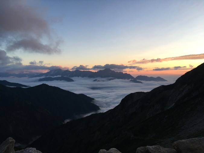
The weather forecast for the week was rainy, and when the bus had driven into Hakuba Valley the clouds were hanging low, covering to tops of the mountains on both sides of the valley. But by the time I reached Happo Ike pond at about 1:40 PM, the fog had begun to lift. I took a coffee break and enjoyed the reflection of the Hakuba range in the pond.
There’s a little shrine at Happo Ike to the dragon god who lives in the pond.
Beyond Happo Ike, you leave the tourists behind. Since I started hiking in the afternoon, I ran into only one other hiker on the way up to Karamatsudake Hut, where I camped for the night. He was an older gentleman who had driven up from Chiba in the morning, so we were on more or less the same schedule. Seeing the sleeping pad strapped to the outside of my pack, he asked if I was tent camping. He was curious how heavy my pack was. I said that the scale at the bottom of Happo One said 11 kilograms. He said his was 12 kg, and he was planning to stay at the hut, which meant he hadn’t packed food, tent, or sleeping bag… how come my pack was so light? Then, he realized he was carrying 2 kilograms worth of camera kit. I said, that totally explains it, because my tent is only 750 grams and my sleeping bag even less than that. That’s one benefit of having not gotten crazy about photography while hiking… yet.
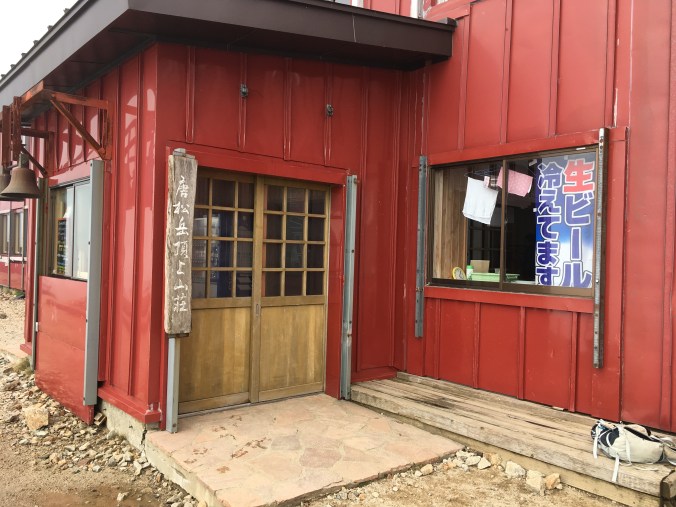
I completed the anticipated 4-hour hike from Happo Ike Hut to Karamatsudake Hut in just about 3 hours. It’s a short hiking day, but I’d been up and traveling since 5 AM and was satisfied to call it a day. Welcomed by a sign offering draft beer, I checked-in and paid 1000 yen for a tent site. After a brief chat with the girl at reception about mountains in Taiwan, I set up camp. The campground consisted of scattered sites down the other side of the ridge from where I had climbed up, and offered amazing views of the Tateyama peaks dominated by Mt. Tsurugi.
Karamatsudake Hut
What my campsite looked like
View of Karamatsudake Hut and tent sites
I’m relaxing and unpacking and somehow 1.5 hours disappeared. I climbed back up the ridge to go to the hut to use the restrooms, then returned to my tent to cook dinner as sunset fell on the archipelago of the Kita Alps in a cotton candy sea.
Sunset on cloud-capped Mt. Tsurugi
Scoping out the next day’s hike: looking north across Kaerazunoken
Day 2: Thursday, August 31
Karamatsudake Hut –> Hakubadake Chojo Shukusha (白馬岳頂上宿舎) (8.64km)
I am awakened in the middle of the night by rain inside my tent. It’s condensation being shaken off the inside of my tent by the wind blowing outside. I wiped down the inside of my tent with a small camp towel, changed the orientation of my head (since I had been sliding down toward one end of my tent) and slept much better for the rest of the night.
I had ambitious plans to wake up for sunrise but couldn’t actually motivate myself to get up. Anyway, when I finally got out of my tent there was pretty much zero visibility due to the mist. I packed up my tent and went to the hut to brush my teeth, pee, and make some coffee. Reception at the hut tried to sell me 1L of PET bottled water for 600 yen, but I purchased 1L of unfiltered river water for 150 yen and ran it through my Sawyer filter.
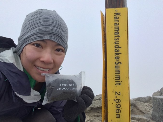
It was imperceptibly drizzling as I started the day’s hike and after about 20 minutes, I stopped for breakfast of a piece of Family Mart chocolate pound cake at the peak of Karamatsudake. It’s wrapper had conveniently puffed up into a balloon at high elevation to keep it from getting smushed in my pack.
400 calories of chocolatey goodness
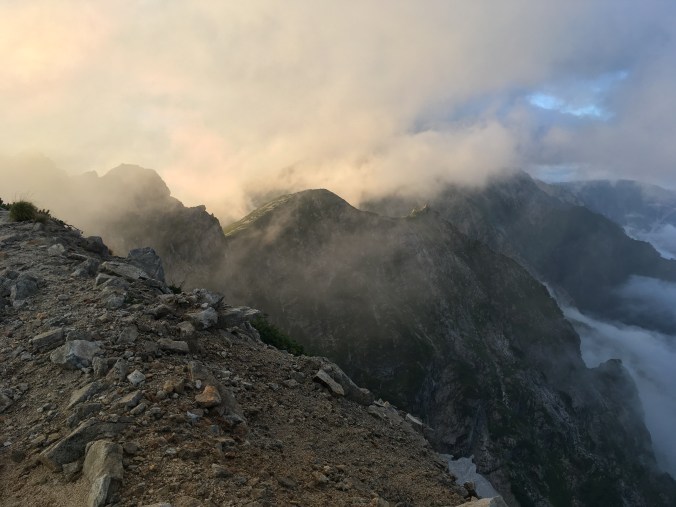
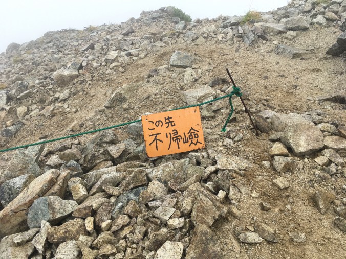
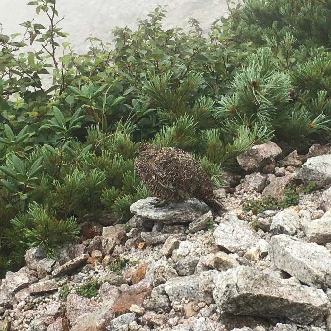
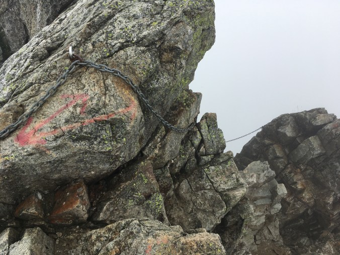
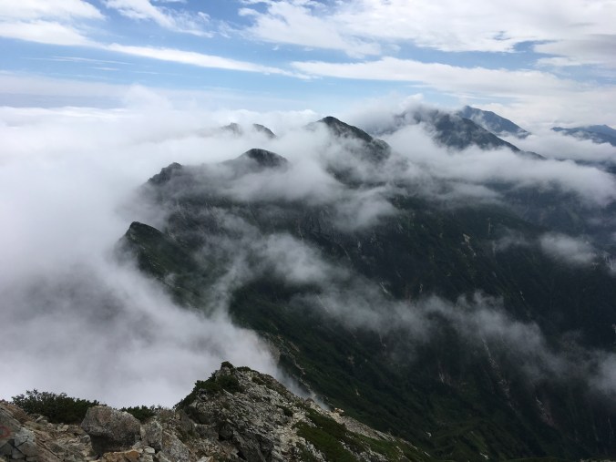
The next section of the hike was a rocky traverse called Kaerazu no Ken (不帰の険), which translates to “Cliffs of No Return”. It looked pretty sketchy based on the trip reports I’d read on Yamareco and my map had a dotted line labeled “danger”. So, in case of heavy rain and low visibility, I had a plan B of going south from Mt. Karamatsu and taking an easier traverse to Mt. Goryu. I was walking among wisps of cloud, but it wasn’t raining so I decided to follow plan A and go for it. Just past the first sign marking the beginning of Kaerazu no Ken, the trail wasn’t too bad. A family of ptarmigan waddled down the trail in front of me, unperturbed by my presence. But soon I had put away my trekking poles and found myself traversing cliffs on chains and swinging around rocky corners trying to stay balanced with a bulky pack on my back. Finishing the traverse without falling to my death, I was rewarded with a huge slogging uphill climb on switchbacks and then some more chains to the top of Tengu no Kashira (天狗ノ頭). From the top of Tengu no Kashira, you could see that the peaks to the south were super rocky and steep compared to the rolling ridge to the north, which looked much less extreme.
Sign warning hikers of the start of Kaerazu no Ken
Ptarmigan
These chains will later make the cables at Half Dome a piece of cake
“I think the trail goes that way?”
“Snow river” in the valley that will not melt through to the next snow season
View south of Tengu no Kashira
View north of Tengu no Kashira
I was pretty spent by the time I got to Tengu Hut. The clouds thinned and parted a bit and I quite successfully dried out my tent and aired out my feet over lunch at a picnic table in front of Tengu Hut.
Lunch, tent drying, and water-getting at Tengu Hut
However, by the time I started back on the trail again, the mist had dropped again and there was no visibility as I crossed the small snowfield after Tengu Hut, making it a bit scary as I couldn’t see where I was going. Then, there was a climb up brilliant white marble (?) scree to the top of Hakuba-Yarigatake. Since there was still no visibility, I took the easy route around Sakushidake (杓子岳) instead of summiting another peak. Past the Hakuba saddle there were supposed to be alpine flower meadows, but I couldn’t really see anything. I finally spotted a sign for the municipal run Hakubadake Chojo Shukusha hut (白馬岳頂上宿舎), paid my 1000 yen to camp out back and warmed up in the restaurant.
Day 3: Friday, September 1
Hakubadake Chojo Shukusha –> Tsugaike Shisenen Ropeway Station (6km)
Sometime during the night, I pulled my Buff down over my eyes and ended up sleeping past sunrise again. It was the coldest night I’d spent so far in my tent and sleeping bag, and when I awoke I stuffed my hiking clothes inside my sleeping bag to warm them up and unzipped the mesh door of my tent to my heat up some breakfast in the vestibule of my tent while still sitting in my sleeping bag. It’s a brilliant blue sunny sky out. Darn it! I missed a beautiful sunrise. After eating, I zipped my tent back up and put on my now toasty warm hiking clothes. The sun was just beginning to warm my tent as well, as I pushed my pack out through the tent door, collapsed the tent and collected my tent stakes. The tent was pretty dry from the sunny morning, so I didn’t have to worry about drying it during the day.
Breakfast
I made my way up to the top of Mt. Shirouma. There is a another huge hut right there! Yesterday, I couldn’t see anything. This is why I like overnight hiking: you get two chances to see stuff. At Mt. Karamatsu, the night before, I had a beautiful sunset, but no view in the morning in the morning. Last night, there I couldn’t see anything when I arrived at the campsite, but this morning there is not a cloud in the sky.
Behind the privately run Hakuba Sanso hut near the peak, there was a spot on the ground that marked each of the landmarks in the distance. Looking southwest, I could see Yatsugatake. Unfortunately, there was no Fuji view that morning. Toward the south, I saw Shakushi and Hakuba-Yari peaks which I crossed yesterday. In the distance, I could see Yarigatake and Mt. Hotaka, and closer Mt. Tsurugi; toward the west, Toyama city and Noto penninsula surrounding Toyama Bay, further west, the Sea of Japan.
Hakubadake Chojo Shukusha Hut
View from Hakuba Sanso Hut
There was more of this view in full 360 degrees from the top of Mt. Shirouma. Toward the northeast was the mellow ridge leading to Mt. Korenge that I would walk that day. The ridge rising above the clouds looked like the backbone of a sleeping dragon. And then it sank beneath the rising clouds.
Dragon’s backbone of Mt. Korenge (View from summit of Mt. Shirouma)
After an initial steep decent, it was an easy and flat walk on crushed rock the size of large gravel. I passed by large cairns lurking mysteriously in the fog. The white rock changed to red, indicating iron content. My map showed a side trail leading on to the site of an old refinery and mine office.
The rocks on the slope up Mt. Korenge tinkled like glass when I walked over them. I picked one up and it felt lighter than it looked. An almost pumice. Atop Mt. Korenge, I took a break for a second breakfast of coffee, nuts and salami. I packed out an abandoned tupperware that obviously had held someone’s lunch in it. (It was a nice tupperware, but I was afraid to open it to wash it out and ended up just throwing it away when I got down to the gondola station at Tsugaike.)
Mt. Shirouma behind me
At Hakuba Oike Hut, I picked up some water (free!) and admired the flat campground looking onto an alpine meadow. Should be pretty on a clear day. Where is the pond? I followed the sign for Tsugaike to the other side of the hut and see the edge of the water in the mist and the trail going around the pond. After following the trail for the while, I think, this is a huge pond! More like a lake? I could only see the edge of the clear green water but it feels like the trail has been going around it for quite a while. The trail becomes some pretty fun rock hopping with occasional X and O symbols directing the way. It was like this all the way to the top of Mt. Norikura, which is not much of a peak but the high point on a flat mountain top. (No use hiking here to snowboard down, you’d just be stuck!) Finally, the sky opens just briefly enough for me to see the whole Hakuba Oike pond and take a photo.
Hakuba Oike pond
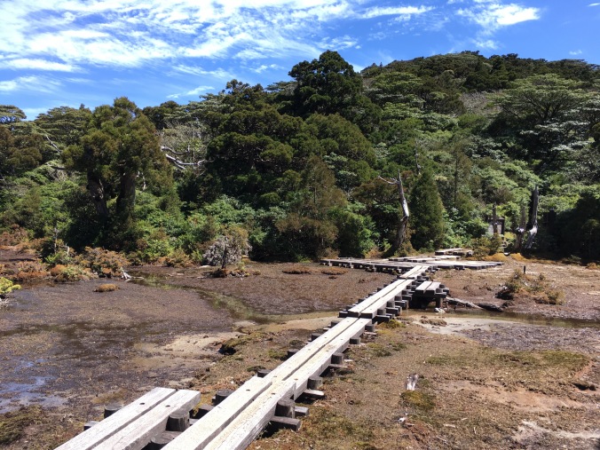
There was more rock hopping until I reached a small snowfield, and after the snowfield the rock hopping got quite a bit more challenging. Climbing down big boulders with a heavy pack on is much more difficult than with only a day pack, because you don’t want to destroy your knees and ankles from impact. Finally, finally, I reached the raised wooden platforms set over a marsh I’d been spying from up above.
The wooden walkway was being replaced, and there were pallets of new wood to be installed off to the sides of the pathway. I hopped over onto one of the pallets and made myself comfortable. Since I didn’t really pack lunch for this last day, I end up cooking half a pack of quick cook pasta and a cube of kimchi jigae soup, since that’s what I have left. Yes, I have become one of those Japanese hikers that cooks hot lunch!
Lunch break!
As I was packing up after my lunch break, one of the workmen made his way over and asked me when I was heading down. He was looking for someone to walk down with. I’m a little weirded out initially, but he started telling me about his job. He and his team have been up at Tsugaike since July living in two trailers by the top of the Tsugaike ropeway. His company also did the wooden walkways at Happo-Ike, which I passed the first day of my hike, as well as at Mt. Naeba and Mt. Hotaka. I commented that it was a nice job to be able to work in all those beautiful places. He replied that he only comes to the mountains to work, his hobby is golf. He pointed out some bear scat on the trail. I haven’t seen a bear while in Japan yet!
We ran into a hiker testing the water at a spring. This water is safe, he called out to us, so we stopped for a drink and a chat. This typical retiree hiker explained he thought it would be boring to just set a goal of climbing the Hyakumeisan, so his personal goal is to test all the water sources on the Hyakumeisan. He says that so far, all the water sources he’s tested have been potable. Good to know right?
Guided by someone who’s walked up and down the trail everyday for months, I made it down to Tsugaike ropeway safely, with no injuries and finished my hike in good time. After getting to the bottom of Tsugaike Ski Resort, I consulted the bus schedule. I could’ve either hopped a bus direct from Tsugaike back to Tokyo, but I ended up busing back to Happo Bus Terminal where busses are more frequent so I could catch an onsen before returning to Tokyo.
The ski resorts of Hakuba Valley come into view
Tsugaike Gondola, the end of my hike
Logistics and Costs
I picked Hakuba for this last minute hike because the logistics were easy. I took a highway bus to and from Shinjuku, ski resort gondolas and lifts to and from the trail heads, and one of the Hakuba town buses from Tsugaike back to Happo Bus Terminal.
I wouldn’t have done Kaerazu no Ken by myself if it was raining. If it had been raining that morning at Mt. Karamatsu, my Plan B was to go south to Mt. Goryu, instead of north to Mt. Shirouma, because that ridge is less dangerous. Kaerazu no Ken was pretty sketchy and since I was alone, I was very careful and it took me 1.5 times the estimated course time on the map to complete it, because I didn’t want to lose my grip or footing anywhere and fall into an abyss…
There are two huts at the top of Mt. Shirouma, Hakubadake Chojo Shukusha (白馬岳頂上宿舎) and Hakuba Sanso (白馬山荘). Hakuba Sanso does not have tent sites.
There is free water at Tengu Hut, Hakubadake Chojo Shukusha and Hakuba Oike Hut, but not at Happo Ike Hut or Karamatsudake Hut.
The Shinetsu Trail is an 80 kilometer trail from Mt. Madarao to Mt. Amamizu along the ridge that separates Nagano and Niigata prefectures. I found out about it while hanging around Iiyama Station waiting for a Shinkansen when I was living in Nozawa Onsen. In Japan, it’s a rare “long trail” designed for multi-day trekking and not peak-bagging. It is not high elevation (the tallest peak is Mt. Madarao at 1382 meters) and there is not very much elevation change. There are no Hyakumeisan and no fancy mountain huts along the trail. Instead, the trail crosses many historic mountain passes between Nagano and Niigata, used for trade and travel between the domains of Shinshu and Echigo once upon a time, some of which have now become roads which provide easy access to various points of the trail. Some local minshuku down in Iiyama valley are signed up to provide accommodation for hikers on the Shinetsu Trail and will drive you to and from the appropriate trail heads each day. Or there are six designated tent sites along the trail. Four are barebones sites with pit toilets and a water source maintained by the Shinetsu Trail Club, an NPO, and two are existing commercial camp facilities.
Since my interest in the Shinetsu Trail was to use it as a practice hike for the JMT, I planned the hike as a 5 day 4 night tent camping (“tento-paku” in Japanese) backpacking trip and my friend Genna from Nozawa hopped along.
Genna and I catch the Hakutaka 553 Hokuriku Shinkansen departing Tokyo 7:52 and arriving in Iiyama at 9:43. I had planned for us to catch a 10 AM bus from Iiyama Station to Madarao Kogen Hotel to start the hike. But, when we arrive at the bus stop in Iiyama, it turns out that the 10 AM bus only runs on weekends and holidays. Rookie mistake. So, we get a ride from a concerned taxi driver who warns us about mama bears with their cubs.
Since we take a cab, we are able to get the driver to drive us all the way to Chiroru trailhead (where the main lift ticket office is for Madarao ski resort in the winter). The climb up Mt. Madarao is basically straight up the ski slope, steep and hot, with no cover and, frankly, not very fun.
I climbed the last bit to the peak from the top of the highest chair lift twice last winter for a backcountry tour. I thought it would be interesting to see what the mountain looked like in the summer. Everything looked totally different. The last time I was up there we hiked to the right of a huge cornice.
Hiking up Mt. Madarao in February
Last winter, our guide Andy from North Nagano Outdoor Sports had explained that the snowpack on Mt. Madarao is very stable because the short bamboo (sasa) covering the mountain creates a great bonding layer for the snow. There were many bamboo shoots poking out on the hiking path but nothing tender enough to pick and eat.
At the fork right before the peak, we run into two sprightly young guys (college students?) with sleeping pads strapped to the outside of their packs. We run into them again loitering around the signboard at Akaike when we finish our first day’s hike around 4 in the afternoon. The boys pressed on and I found out from Instagram later that they thru-hiked the whole trail in 3 days and 2 nights.
It is an easy hiking day. We get to the top of Mt. Madarao to begin the trail just before 11:30 AM and reach our campsite at Akaike before 4 PM. We hike through beech (buna) and cedar (sugi) forests and couple small marshes, one full of skunk cabbage (already past flowering) and the other full of frogs that sings a chorus for our lunch. They were so loud!
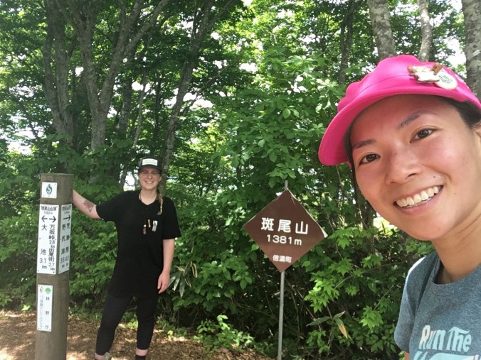
Official start point of the Shinetsu Trail
Lake Nojiri
Mt. Myoko – looked so cool! I want to climb Myoko now…
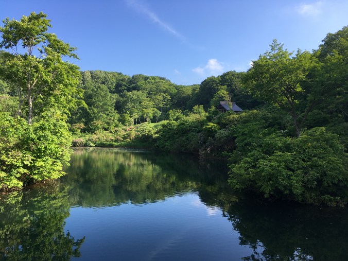
Idyllic Akaike (That little building had running water and flushing toilets!)
After we set up our tents, Genna wades into Akaike for a swim. I sit at the edge icing my ankles saying, “I’m sketched out by unknown bodies of water.”
Genna goes, “Hope there aren’t any monsters.”
“You mean like that?” I point at a huge arm-length white koi swimming straight towards her, freaking Genna out.
My second hiking fail of the day is when I pull out my camp cook-set and realize I brought an empty fuel canister instead of a full one. Good thing Genna has brought a 230g canister that ends up comfortably lasting us the entire trip.
At night, the stars are so bright above our campsite. Each time I wake up without moving from my sleeping bad, I see the Big Dipper was hanging a bit lower as it descends toward the to horizon.
Day 2 — Tuesday, June 20
Course: Akaike (赤池) → Katsuraike (桂池)
Distance: 20.1 km
I wake up at 5:30 to a lot of condensation on the inside of my tent. I use my tenugui to wipe off the condensation, then wring out the tenugui and use it to wash my face on the way to the toilet. We cook breakfast and make coffee and set off at about 7:30 AM. We have 20.1km to cover in a day and neither of us has ever hiked that far before.
We find a beautiful panorama of Mt. Madarao, Mt. Myoko (妙高山) and Mt. Kenashi (毛無山) from a clearing just past Numaike (沼池) / Nozomiko (希望湖). So we take a snack break (second breakfast!) to enjoy the view and discuss that we should’ve camped there instead. For next time!
After Wakui (涌井), most of the trail is on forest road (林道) with little cover on a hot and sunny day. 31 degrees when I check my phone. We break for lunch and put out damp tents to dry at Tomikura Gap (富倉峠) around noon. Just past Tomikura Gap are sweeping views of Iiyama Valley. Apparently, this is where famed warlord Uesugi Kenshin, daimyo of Echigo province (present day Niigata), set up camp to battle his rival Takeda Shingen who had conquered Shinshu (present day Nagano) during the Sengoku period (16th Century).
Around 2PM, we are hot, sweaty and exceedingly grateful to reach a nice little pentagonal hut perched on the ridge near the top of Kuroiwayama ( 黒岩山) where there is a nice cross breeze. We strip down to sports bras to dry our t-shirts in the cool breeze.
We’d been a bit intimidated by the distance in the morning, but since most of the trail was forest road or old trading routes (graded for horses and ox carts), the trail was pretty flat the whole day and we arrive at our second campsite at Katsuraike about 3:30PM. We take a brief swim in Katsuraike to cool off (too hot and sweaty to care about monsters) and then sunbathed a bit to dry off. The forecast for Wednesday was rain and cloud cover began to come in at dusk. At Genna’s first report of hearing a mosquito, I zip myself into my tent for the night.
Katsuraike Tent Site
Katsuraike
Day 3 – Wednesday, June 21
Course: Katsuraike (桂池) → Sekida Gap (関田峠)
Distance: 11.4 km on the Shinetsu Trail, plus 1.5 km to campsite
I wake up to a large tick clinging to the screen door of my tent looking like a kid trying to lick ice cream through a store window. Nope, I think, and flick it off with my finger into the grass somewhere. It’s a rainy morning but luckily there’s an empty rundown old house at the campsite serving as a makeshift shelter. In the shelter, we hang our tents to dry and cook breakfast. We get a late start to the day around 9AM after the rain lets up a bit.
Getting water at Taroshimizu spring (太郎清水)
My rain jacket wets out almost immediately and turns into a sauna suit. The first 3.5km of the trail after Katsuraike is a tough uphill climb to the top of Togari Onsen Ski Resort with two small stream crossings along the way.
When we reach Togari Onsen Ski Resort, we climb onto one of the ski lifts to dry off and cool down.
Togari Onsen Ski Resort
Then there is a bit of a climb up the ski hill. Shortly after we get off the ski slope and back into the trees again, the rain stops. The clouds lift first over Iiyama valley and the wispy clouds hanging over Nozawa Onsen and the Chikuma River (千曲川) were so pretty. Thanks to the rain, we’re able to see frogs and mushrooms, snails and slugs on the trail. So, all in all, I’m actually glad we had to hike in the rain.
The narrow knife ridge up to Mt. Nabekura (鍋倉山) is definitely the highlight of the trail. We could see all the way to Naoetsu (直江津) and the Sea of Japan on one side and all the way up and down the Chikuma river valley on the other, all at once! Though the rain had stopped, it was still extremely windy from the storm and I had to remember to pay attention to my feet and not fall over.
Nagano side
Niigata side
Since the ridge is so narrow and windy, at some point near 1PM we simply squat straight down on the trail and eat a well-deserved lunch. We rest again at the top of Mt. Nabekura and again at Mt. Kurokura (黒倉山), where the sun comes out and we are able to dry our tents and put away our rain jackets.
Yesterday it was 31 degrees but today the temperature was in the low teens. I wore my thin leggings and merino wool long-sleeve hiking shirt (which dried like a champ), but otherwise probably didn’t need to bring these extra clothes
We detoured off the trail to Chayaike (茶屋池) which was worth it because it was a very pretty pond and had a lovingly maintained toilet.
Our campground for the night, Green Pal Kogensou (グリーンパル光原荘) had apparently not opened for the season yet. It was still very windy when we arrived that we spent a lot of time looking for the most sheltered tent site, only to have the wind die down by the time we got our tents set up. We cooked dinner on the deck of the main green building at the campground with a view overlooking the mountains of Joetsu and the Sea of Japan.
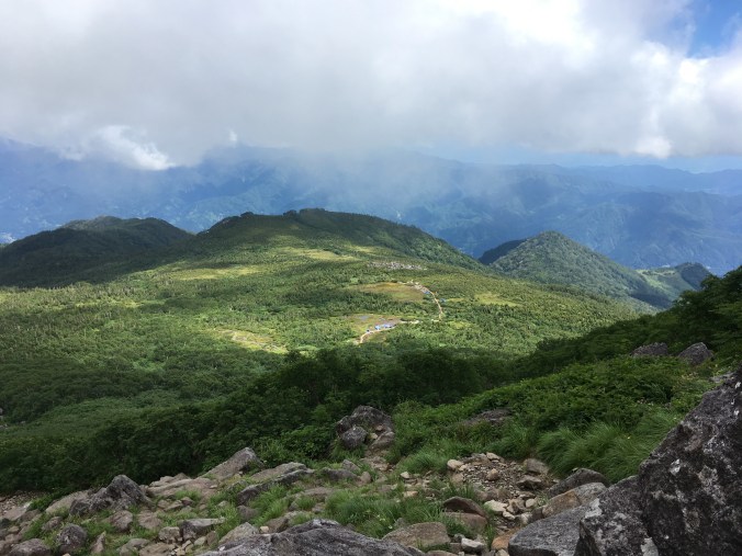
Day 3 on the Shinetsu Trail was green tunnel and killer vistas, what I imagined it would be like hiking the ridge between Nagano and Niigata. Day 1 was tromping around Madarao Kogen; Day 2 was mostly road walking; Day 3, we got to the good stuff.
Day 4 – Thursday, June 22
Course: Sekida Gap (関田峠)– Nonomi Gap (野々海峠)
Distance: 18.9 km on Shinetsu Trail, plus 1.5 km from campsite
I was thinking while hiking that there would not be much to say about Day 4, except that we started to see snow on the trail: snow patches tucked in shady areas, snowmelt ponds and muddy depressions where there had probably been snow until very recently.
Previous days we noticed that if we came upon a muddy bit, there would be a lot of flies. Well, today was pretty much all muddy, what with yesterday’s rain and the recent snowmelt, so there were a ton of flies.
The trail became challenging but monotonous; a lot of slippery, muddy ups and downs and “limbo trees,” what we decided to call tree branches/trunks crossing the trail at inconvenient height to either duck under or step over. There were great sweeping views of Niigata, but not as dramatic as yesterday. You couldn’t really see the sea because it was quite hazy without yesterday’s rain.
We emerged at Nonomi Gap just as a group of retirees were being loaded onto a minibus. (They were a hiking group from Osaka thru-hiking the Shinetsu Trail in six days, staying two nights at Madarao Kogen and three nights in Togari Onsen.)
The bus driver asked where we were going and we were able to hitch a ride to our campsite 2km down the road at Nonomi pond (野々海池).
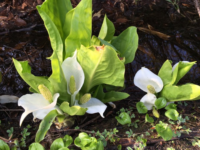
Skunk cabbage blooming at Nonomi pond
The campsite looked nice enough. But as we put our tents up, we attracted a swarm of black flies. And then, they started to bite. The taps at the indicated water source were not running (probably turned off to prevent pipes from freezing in the winter), so we had to go down to the lake to get water, while being tailed by a vicious swarm of flies. Genna daringly waded into the pond with a plastic grocery bag to get less scummy water to fill the Sawyer Squeeze bag with and we both had to sacrifice ourselves to some flies to filter 4 liters of water for camp. Teamwork!
Our hardship turned out to be unnecessary, because on the way back I stopped by the toilet and found out the hand-washing tap by the toilet was running. It makes a good story (did I mention Genna almost stepped on a snake, I screamed my death scream and the nice guy working on getting the campsite ready for the season hopped in his k-truck to check if we were okay?), and I guess there had to some Type II fun on our trip.
Flies were still swarming our tents, so we boiled a pot of water, split it in two and literally dove into our tents. There must’ve been around 200 flies swarming the fly of my tent. The sound of the flies flying into the fly of my tent sounded like rain. I killed the 5 that got inside my tent when I dashed in. Then, there was nothing to do but eat and get ready for bed. I was pretty happy I didn’t have to get up and go to the bathroom at any time that night.
Distance: 6.2 km on the Shinetsu Trail, plus ~5 km to get to the trail and off the trail from our campsites
I wake up to a brilliant symphony of birdsong. And only 8-10 flies still hanging around my tent. I have not left my tent since 6-something yesterday evening and contemplate getting up to go to the toilet. I check if Genna is awake yet and then go back to sleep. I wake up again and get ready for the day by packing up everything except what I need to wash up and make breakfast.
Having confirmed that Genna is up, I work up the courage to exit my tent, go to the toilet, wash my tenugui and brush my teeth. Flies do not follow me, and things are looking good. But, when we start boiling water for breakfast, the swarm reappears and breakfast is another split the hot water and dive for tents affair. After we’ve finished eating our breakfasts, it’s a non-stop dash to take down tents, pack up and leave, barely stopping at the toiler sink to fill up on water. We have to keep moving or the flies will catch up. I think we’re on the road around 7-ish, but I didn’t keep track because our priority was just to beat the flies. We look like Pigpen from the Peanuts comics, being followed by a little cloud of flies.
Up the trail from Nonomi Gap we reach a sunny clearing looking down over Niigata where the trail hooks 90 degrees to the right. We stop to make some coffee and dry our tents. It’s okay for a bit and then we start getting bitten again. We’re just finishing packing up when the group of senior citizen hikers from yesterday appears. As we move on ahead, I overhear their guide explain that our choice of coffee spot is the northernmost point of Nagano Prefecture.
Misaka Gap, final pass before Mt. Amamizu
View of Niigata from Misaka Gap
Then it’s more up and downs through muddy bits and the most significant snowfield we cross on the trail (still pretty small) and before we know it, we’ve reached to top of Mt. Amamizu, the official endpoint of the Shinetsu Trail. It’s only 10AM. We take a few photos, finish our coffee and get moving again before the flies gather too thickly.
Another uphill. “Guess what day it is?” “Leg day!”
Finish! Official endpoint of the Shinetsu Trail.
Down toward Matsunoyama trailhead, we meet an old man picking bamboo shoots with bear bells that sound like pretty wind chimes. In 80km, we’ve walked a bit backwards in the spring season, despite having come down in elevation. At the trailhead, we meet to bus driver that gave us a lift yesterday and chat for a bit about their group and he points us in the right direction for our last campsite at Daigonji Campground.
We decide to road-walk rather than take another trail to the campsite after I ask Genna the rhetorical question, “Have you had enough nature yet?”
We get to the campground just past 11 and the manager is not in yet. One of the guys working there cutting grass can’t believe we’ve walked all the way from Madarao and keeps saying “sugoi desune!” and pulls out some folding chairs for us to sit on. I ask if the restaurant is open. It is. So, instead of waiting for the manager, we go to the restaurant and have the most beautiful and delicious hiyashichuka (cold summer ramen noodles) I have ever seen in all my years of living and traveling in Japan.
We put our hats back on for this photo cuz our hair was so greasy and gross. 😛
We also have two beers apiece which get us nicely buzzed since we haven’t had alcohol since??? Then we check in and ask about taking a bath, but the guesthouse is not open yet, so we can only use the shower in one of the cottages. We get the key to a cottage, which has a nice deck with a breeze. I do some laundry in the shower and hang it on the deck to dry and write the last of my trail journal lying on the deck in my underwear. It’s so nice. The perfect temperature, shade, no flies, breeze; a beautiful day. We chill on the deck of the cottage until we get kicked out of the cottage for the next guests to use the shower.
After the hike, we chilled for the rest of the day and the next at Daigonji Campground doing nothing except laying around eating the rest of our food.
Our view during dinner at Daigonji Campground
Post-hike Reflections / Advice
I was discouraged from doing this hike prior to July 1 by the Shinetsu Trail Club because they hadn’t completed train maintenance until last weekend and there was still a bit of snow and felled trees on the trail. Except for our last camp site, none of the tent sites we used were officially open. It wasn’t a problem because no one else was there and there were toilets and water sources at each camp site. I think the trail would be beautiful in earlier spring green, perhaps from May.
I’m glad I did not wait until July to do the trail because it was already really hot. It’s not high elevation, so it really did not cool down at night either. I only had condensation inside my tent the first night. In terms of warm layers, all I should have packed was a 100 weight fleece. I tried sleeping without my long johns on one night but since I use a quilt, my thighs were sticking uncomfortably to my sleeping pad so I had to put them on.
The prime season for hiking the Shinetsu Trail must be Autumn. There were so many varieties of Japanese maple lining the trail it must be very beautiful for fall colors.
Out of season red leaves. A teaser for fall?
The Shinetsu Trail is still not so well-known among Japanese hikers. It’s refreshingly undeveloped, but well-maintained and adequately marked. Even though there is very little infrastructure on the trail after Togari Onsen, you are never more than a few hours walking to a town if you need to bail or get help. (I also had cell phone coverage the entire time.) It was a great trail to do a beginner long-distance trek. Perhaps because we were hiking before the official start of the season, the only other hikers we saw were the two boys the first day and then the group of ~16 retirees from Osaka that gave us a lift on the end of the fourth day. We did see a few other people during our hike doing forest road maintenance or picking spring mountain vegetables.
Matsunoyama Onsen near the end of the trail is a very cute little hot spring village and I’d probably try to stay there next time because Daigonji was still pretty much the middle of nowhere. Good thing Kiwi Sig Other showed up with a rental car so we could get back to civilization. It’s probably pretty easy to hitchhike down to civilization from the trailhead as the only people around are friendly locals who know about the Shinetsu Trail. The magic onsen water cured the itchiness of all my fly bites. Not bad for one of the Three Famous Medicated Onsen of Japan.
Contact me if you have any questions about hiking the Shinetsu Trail!
Ah, springtime in Tokyo. The time of the year when you seek an easy weekend day hike to get a nice view of Mt. Fuji while it still has a snow cap. I hiked Seihachiyama (清八山) with friends on May 20 and it was the best view of Mt. Fuji I have ever seen. Unlike a lot of day hikes from Tokyo that purport to offer a Fuji view, the view from Seihachiyama is completely unobstructed. Besides the killer views, what I liked about this hike is it is accessible directly from a train station, the trail is well-graded for a Japanese trail and it was not crowded at all. Unlike the Okutama area, the Otsuki area in Yamanashi on the Chuo Line apparently offers enough hiking options so that hikers coming on the morning trains from Tokyo are well-dispersed even on Saturday. (Our same group hiked Mt. Takagawa (高川山) from Hatsukari Station (初狩駅) to Otsuki Station (大月駅) last April.) It’s definitely my favorite area for day hikes from Tokyo now.
This is the hike I would take friends visiting from abroad on if they say they want to see Mt. Fuji. (I will also offer it as an alternative for those poor misguided visitors who want to climb Mt. Fuji. Please read “Why You Should Never Climb Mount Fuji” if you still need to disabuse yourself of any romantic notions of climbing Mt. Fuji.)
Access: The hike begins and ends at Sasago Station (笹子駅) on the JR Chuo Line. We took a Chuo Line rapid from Shinjuku Station which departed Shinjuku at 7:07AM and arrived at Sasago at 8:59AM, which places this hike squarely in the range of within 2 hours from Tokyo.
Distance: 13 km
Time: 6-7 hours at a comfortable, not-rushed pace. (No need to rush because trains are reasonably frequent from Sasago Station.)
Difficulty: Easy. Trail is well maintained, pretty soft and flat underfoot and there are no rocky scrambles except the last few feet leading to the top of Honjagamaru. Last part of the trail coming down was a bit steep since it often seems like Japanese trail crews have not heard of “switchbacks” so wear proper footwear for traction and ankle support.
Map: This map is a photo of the trail map in front of Sasago Station. Red arrow marks Sasago Station.
The Hike: We basically followed this plan from Yamareco: https://www.yamareco.com/modules/yamareco/detail-365365.html. Starting from Sasago Station, we went west along the Route 20, turned left after crossing Jinego River, went through Oiwake Tunnel and walked up the forest road past a power station to the trailhead. At the trailhead, there was a fence with a net entrance you had to untie and open and close and retie behind you to prevent deer from entering an area where they are trying to restore vegetation. Then it’s a straightforward uphill to the top of Seihachiyama (1593m). We took a leisurely lunch on the top to enjoy the view. After the peak, the trail follows the top of a ridge to Honjagamaru (1630.8m) and then starts a mellow descent through some nice shady woods. While you follow the ridge, the trail is really nice, easy walking. Then, we forked left back towards Sasago Station, crossed a forest road, and continued down a soft but somewhat steep trail to the station.
Onsen: There is a public day onsen facility Sasago Onsen (笹子温泉) near where we turned off Route 20 to begin the hike. We didn’t have time to check it out since some of us had to boost back to Tokyo.
Photos:
The hike begins among idyllic Yamanashi inaka
After the forest road, there is a forest restoration area that is fenced off from deer. The short trees in this area give you an alpine feel and great views of the surrounding mountains.
Postcard view of Mt. Fuji from the top of Seihachiyama (1593m)
View of Mt. Fuji from another lookout just 15 min beyond the peak of Seihachiyama
So, you’ve read about my Yakushima adventure and want to plan your own. This post provides information about my trip that may be relevant to your trip planning.
My Yakushima adventure
My Yakushima trip was very spur of the moment. I had already purchased a plane ticket to Fukuoka for a Kyushu ceramics tour and then decided to attach Yakushima to my Kyushu trip. This was literally the first time I just went traveling without knowing where I was going to sleep every night.
I used as reference http://www.yakumonkey.com/ and http://www.yakushimalife.com/. But once I was on the road I didn’t have reliable Internet, so I bought the Yama to Kougen Yakushima hiking map (山と高原 is the series of maps used by most Japanese hikers) when I got to Kagoshima and it became the primary resource I really used to plan my trip. The map comes with a little handy guide with trail descriptions and model routes for day hikes and multi-day traverses. It also has campsite and hut information and phone numbers for emergency, lodging, transportation, etc. It is completely in Japanese.
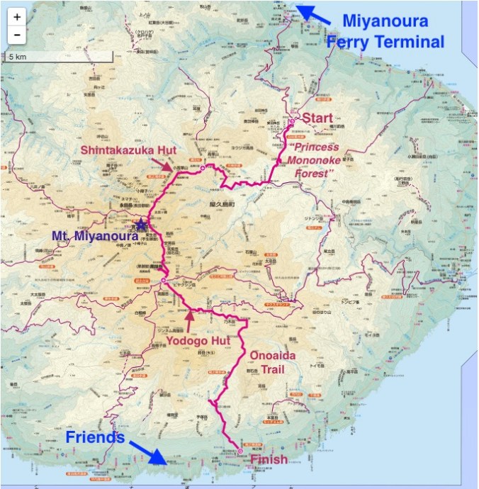
Why I like to call Yakushima “Choose-your-own-adventure-land” is it is a really easy place to go with no plans. According to the Internets, the campsites are rarely crowded and no reservations are required (or taken) for the mountain huts. (Of course, I would avoid Golden Week or any Japanese public holidays.) There are six mountain huts. Two are located close to a trailhead and four are centrally located high up in the mountains around Mt. Miyanoura. The two located near the trailheads — Shiratani Hut and Yodogo Hut — make it possible to catch a ferry from Kagoshima in the morning, take a bus to a trailhead in the afternoon and stay at a hut the night you arrive. (I didn’t need to bring a tent, I just wanted to test out the one I bought for the JMT.) All trails are connected and lead to Mt. Miyanoura, and the centrally located alpine huts mean there are plenty of places to retreat in case of bad weather.
Itinerary
My plan when I arrived on the island was:
Day 1: Get oriented. Camp in Miyanoura.
Day 2-4: Hike for three days staying 2 nights in mountain huts.
Day 5-6: Chill at South Village youth hostel with friends.
Kurio Beach rest day
Food
I purchased ~3500-4000 yen worth of food for my 3-day hike from a grocery store in Kagoshima, consisting of instant ramen, instant miso soup, tea, instant coffee, nuts and chocolate, bread, tuna, granola biscuits and cheese. I would recommend purchasing food on the mainland because there is more selection and it is cheaper. However, there is a relatively large supermarket at a shopping center very close to the Miyanoura tourist info center.
After the hike I spent maybe 4500 yen on food in 2 days while staying at South Village. We bought stuff from a grocery store in Kurio and went out to a nice izakaya for Brig’s b-day.
Transportation
I had to take the jetfoil to the island because the normal ferry was under maintenance when I departed. The jetfoil cost 8400 yen and takes about 2 hours. Website here.
On the way back I enjoyed riding on the normal ferry — Ferry Yakushima 2. It costs 4500 yen and takes about 4 hours. It’s a nice ferry with a gift shop, cafe, various seating areas, and library, which I appreciated because I didn’t bring any reading materials. I borrowed a book and learned about the geology on Yakushima. I also struck up a conversation with a 70-year-old hiker (we identified each other by our backpacks) from Fukuoka who has been to Yakushima over 60 times and plans to make it to 70 trips by the end of the year. He gave me a lot of great tips for my next trip to Yakushima. There was also an amazing view of Kaimondake, Kyushu’s little Mt. Fuji, from the ferry.
There is also a municipally run overnight ferry that is 3000-some yen. My friends took it and said it was okay. It’s the cargo ferry and docks overnight at Tanegashima. The issue with the overnight ferry is that it doesn’t leave from the main ferry terminal in Kagoshima and it’s a bit of a mission to get to the right ferry terminal.
Jetstar flights between Kagoshima and Narita can be had from about 6500 yen each way.
On the island I relied on the bus. There is a bus that goes pretty regularly on the main road most of the way around the island, maybe once an hour. For hikers, there are four buses a day to Shirataniunsuikyo from Miyanoura, and two buses a day to Yakusugiland from Anbo (the other main town on the island). For an idea of bus fares, here’s what I actually spent:
Bus from Miyanoura to Shirataniunsuikyo – 520 yen
Bus from Hirauchi to Kurio beach – 500-some yen each way
Bus from Hirauchi to Miyanoura Port – 1870 yen
Lodging
The first night I ended up illegal camping (oops) at Oceanview Campsite. There isn’t much in the way of facilities there, but it was free.
The 2nd and 3rd nights I stayed in the mountain huts. These are free, but I paid the recommended donation of 2000 yen for overnight campers in the national park.
After my hike, I spent two nights tent camping at South Village youth hostel. It was 1080 yen per night for “camping” with access to a well-appointed guest house with kitchen, dining and lounging areas, big screen TV, washers/dryers, bathrooms, showers and private hinokiburo! The staff were really nice and I definitely want to stay there again. (Actually, I would love to work there…) The website says they only take reservations for 3-nights or longer, but you can stay there for a shorter period of time depending on availability.
Tent site – raised wooden platforms because Yakushima is notoriously rainy
Guesthouse kitchen and dining area
Guesthouse Japanese style room w/ massage chair (I used it)
Guesthouse western style room with flatscreen and a selection of DVDs
For Kagoshima lodging I stayed at Green Guesthouse Kagoshima. A capsule is 2300 yen/night (single sex dorm was full when I went). It is just okay. The building shakes when large trucks go by. Reception wouldn’t accept my takkyubin in typical inflexible Japanese service manner. (I get that they are small and don’t want everyone to send their luggage ahead, but I sent my sleeping pad and trekking poles to arrive the day I checked in and after I checked in they still wouldn’t just receive the package for me. I had to wait for redelivery in person.) Wifi was spotty. But it’s less than 5 min from the ferry terminal, so would probably stay there again if going back to Yakushima on a solo trip.
Moneys
In summary, for 6 days, 5 nights on the island, I spent around 20,000 yen not including the cost of getting to and from the island. Including cost of getting to and from the island from Kagoshima, staying a night in Kagoshima (which you have to do because of ferry times unless you take the overnight ferry) and the cost of flights to and from Tokyo, I spent about 50,000 yen on my trip to Yakushima.
When everyone’s packing up and leaving Yodogo Hut in the morning I catch dad from Morioka and inform him that, after sleeping on it, I have decided to take Onoaida Trail (尾之間歩道) and end my 3-day journey at Onoaida Onsen (尾之間温泉). I thank him for the confidence boost. If he thinks I can make it to Tachudake and back down to the 3-something PM bus out of Yakusugi Land, I should be able to make it down Onoaida Trail to the south of the island in good time. It’s going to be all downhill, right? I loved feeling like I was the only person on the trail yesterday so I’d like to go off the beaten path, I say. Before I really looked at any maps, my initial idea had been to hike north to south since my friends are staying at South Village, and I think there will be a sense of completion to say I hiked north to south across the island to meet them. He thinks its a fine idea and since we have both been hiking faster than the standard estimated course times thinks I’ll make it to Onoaida Onsen in 5 hours, which means I could probably finish before it starts to rain. We bid each other farewell and good luck.
Yodogo at dawn
I arrive at Yodogo trailhead in less than an hour, use the toilet and ask the ranger about the weather. He asks me where I am going. I say, Onoaida Onsen, I hope to make it there before it starts to rain. The trail is long but you should not miss Janokuchi Falls (蛇之口滝) on the way down, he advises.
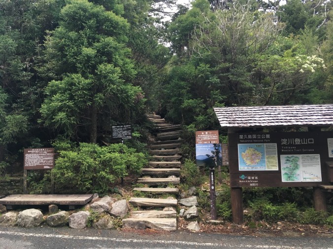
Yodogo Trailhead
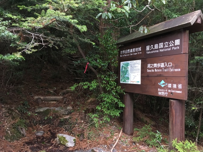
Onoaida Trailhead
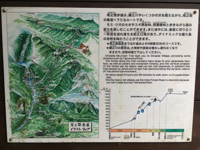
I study the trail description. 8.5 km down to the junction with Janokuchi Waterfall and then 3.5 km to Onoaida Onsen. “It takes about 6 hours and 30 minutes to walk down to Onoaida-onsen Spa.” Easy-peasy.
Description at Onoaida Trailhead
“Onoaida” means “between the ridges”. The little trail guide that came with my map, says Onoaida Trail is impassable if the water level at Tainokawa crossing (鯛之川出合) is high, there are numerous stream crossings and the trail may not be well-marked, GPS is advised. It has not rained in the past two days, so I figure I’ll be fine. As I hoped, the trail does not look well travelled, but I identify a set of fresh boot prints, and it is reassuring to know that at least one other person thinks the trail is passable today.
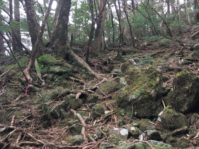
According to the hiking etiquette book I received at Shirataniunsuikyo (白谷雲水峡)trailhead, if you use trekking poles, you are supposed to put rubber caps on the tips of your poles to protect the environment. I didn’t bring rubber tips with me and though 90% of the other people were using rubber tips, no one had called me out so far, not even any of the licensed guides. I figured that staying safe and not spraining an ankle was more important than following the rules, so I used my poles with their normal carbide tips anyway, but I did try to keep my poles on the trail, on wooden boardwalk or gravely or hard rock surfaces and away from any tree roots or moss covered surfaces. This was no longer possible as the trail seemed to consist entirely of tree roots or moss covered surfaces.
It’s a few minutes past 7AM when I start down Onoaida Trail. By 8:30 AM, I reach what must be the lookout point to Nogidake (乃木岳). According to the map at the top of the trail, that places me about 3 km in and more than a quarter of the way down the trail. I’m making good time.
Nogidake?
So far Onoaida Trail is like a better version of Shirataniunsuikyo, with a lot of interesting mosses and fungi and other plant life.
About 9:15 AM I’m at the first stream crossing, I assume it’s Tainokawa and that I’ve made it another kilometer as I climb up the other side.
Then it’s an endless repetition of climbing down to a small stream, rock hopping across it and climbing up the other side. Except the streams get bigger and bigger as I head down.
The trail is well-marked with pink tape, though sometimes I reach one piece of tape and must spin around, tiptoe or duck down to find the next piece of pink tape. A few hours in I find myself turning a corner peering around for the next pink tape, locating it and exclaiming, “You’ve got to be kidding me!”
A sign along the trail explains that Onoaida Trail is an old logging route from the Edo Period (circa 1600), when yakusugi roof shingles were contributed by the locals to the lords of Satsuma Domain and up to first Toyotomi Hideyoshi and later the Tokugawa Shogunate. Since yakusugi are so large, they were cut into shingles at the site where the tree was felled and bundles of shingles were carried out of the mountains by people on foot. “Think of the labor of the men who laid out the stones of the trail,” exhorts the sign. A large part of the trail is a jumble of moss-covered stones. The trail description calls these “moss covered stone steps” which sounds very romantic and benign, but in reality, they do not resemble steps at all, they are slippery and there is no where to put your foot flat. In sections, it is obvious the trail has washed out leaving a red mud pit to climb around, or if that is not possible, down into and out the other side. I also climb over or under felled trees (at one point I almost have to take off my pack to get through). I slip and fall and scrape up my palm, bang up my shins, twist each ankle more than a few times and will later develop a giant bruise on my hip. (Later I learn that since it was a high snow year, the trail is probably in especially bad condition.)
It’s 1PM, I have been telling myself that I will break for lunch at the resting pavilion by the fork to Janokuchi falls but it is nowhere in sight. I’m starting to get worried. I’ve stopped observing the plant life along the trail and stopped taking photos.
I’ve already been hiking for seven hours, six on this god-forsaken horrible not-trail.
There’s a rustling in the brush and four young guys, probably in their early 20s and judging from their accents probably English, appear about 10 feet down the steep trail from me. The forest is so dense you can only see that far ahead.
“How much farther to the waterfall?” I ask hopefully.
“About one-and-a-half hours,” is the reply.
I can live with that. They say they are headed to Yodogo Hut for the night. I tell them I came from there and it’s beautiful. “This is a hard trail isn’t it? Does it get easier past the waterfall?”
“Not really,” says one of them and they proceed to tell me about how the trail is collapsed, they had to climb around it in part. Something inside me collapses in disappointment. I’d been hoping that at least the section of trail from Onoaida Onsen up to the waterfall would be better maintained since that should be the route for a day hike.
“It’s the same up ahead,” I say. “And there are a lot of stream crossings. You guys are the only people I’ve seen on this trail all day and I started at 7 am.”
“That sounds awesome!” one of them says and they plow on.
After they pass, I feel reassured that I am getting close to the waterfall and going to make it out of the woods before dark. Then, I start to feel bad that I didn’t emphasize more that its taken me over 7 hours to get here. Even if I am slow, I am going downhill. It’s going to be hard for them to make it to Yodogo Hut by nightfall; it’s already 1 PM, and it gets dark by 7 PM. Then, I rationalize: there are four of them, they looked like they had the right gear and they are young; they’ll survive.
Finally at 3:15 PM, I reach the pavilion at Janokuchi fork. I drop my pack and trekking poles under the pavilion, drink the rest of my water, stuff some granola cookie things in my face and take a break by running (okay walk briskly) to Janokuchi Falls. Without the weight of my pack, scrambling and hopping is a lot easier.
A welcome sign of civilization!
I’m at the falls by 3:45, spend a few minutes snapping pictures and head quickly back.
I’m still hoping to get a quick onsen before I have to catch the bus. I’m already going to miss the 3-something bus I initially intended to catch, but there’s another one at 5-something.
I’ve started talking to myself. I’m praying to the weather gods out loud: “Thanks for all the awesome weather this trip so far. Thank you for holding off the rain. Please keep holding off the rain.” I’m cheering myself on: “Go team! Good job, Ankles. That’s it, Knees. Just hang in there for another hour. We’ve all been together 35 years and no one has failed us yet. Guess what? We are pretty bad ass! I promise to take good care of you. (When this is over.) We’re going to the onsen!”
The four guys were wrong. The trail following the fork to the waterfall is much easier. Wider and obviously much more travelled. Once you descend a certain elevation the trail becomes loamy and soft, as there is actual soil (including 1 meter of volcanic ash from a nearby explosion 6300 years ago) around the perimeter of Yakushima. The vegetation becomes subtropical and there are palm trees and interesting tropical looking flowers.
At 5:30 PM, I emerge from the bush into the parking lot of Onoaida Onsen. Finish! I sit on a bench in front of the building for a minute and check my bus schedule while the stray cats fed by the guy at the front desk mill around. Great! If I’m in and out in 20 minutes I can totally make the bus.
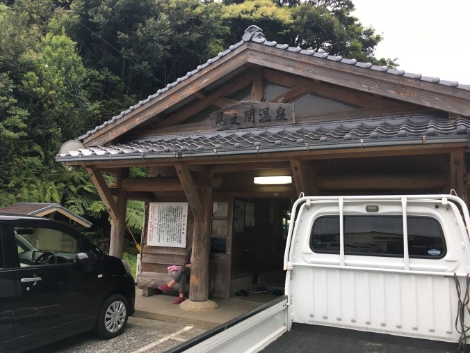
Onoaida Onsen
Onoaida Onsen is written up as “very hot, I don’t know how locals manage to get in” even on Japanese review sites because the spring water comes out of the ground at 49 degrees (Celsius) and the bath is about 46 degees. Whatever, I spent the entire winter bathing almost exclusively in the soto-yuat Nozawa Onsen (average temp around 45) and now think normal onsen temp of 40-42 degrees is nurui (not hot enough). The atmosphere is also a bit similar to the soto-yu at Nozawa Onsen. You have to bring your own soap and towels and while there are a couple shower nozzles, they are exclusively for hair washing. I wash myself like the locals using the bucket method with the hot water directly from the tub in the manner I picked-up in Nozawa. Onoaida Onsen is very barebones but the current wooden building is relatively nice and new and I liked it a lot.
As I’m leaving the onsen, it finally starts to rain. Finally, my rain jacket comes in handy. It’s a 20-minute walk down the road to the main road that circles the island. I make it to the main road just as a bus is about to pass. I flag the bus down, but it’s not the right bus! Turns out I read my bus schedule wrong and missed the bus I wanted to catch. It’s about 6:15 and the next bus going as far as Hirauchi (平内) isn’t for another hour. It starts to rain harder and I retreat to an abandoned vegetable stand alongside the road for shelter to consider my options. I guess I can wait for an hour as it grow dark, or… I can hitchhike?
I’ve never done this before, but I stick out my thumb and the third car picks me up. My driver is a super cool single-mom artist who lives in Hirauchi and makes hand-dyed and hand-sewn clothes. She says she’s originally from Shizuoka but drove down and across Japan looking for a new place to live and when she got to Yakushima, she knew this was the place for her. She drops me off at the hostel and gives me her number to keep in touch.
I check in to South Village and contemplate staying in a bunk instead of setting up my tent in the rain, but a bunk is three times more expensive than a campsite and campers get access to all the same common facilities. I’ve also hauled my tent for three days all the way across the middle of the island. The campsite is composed of raised wooden platforms, so I give myself a crash course in setting up my tent with concrete blocks and rocks instead of stakes. I manage to do okay. My friends Tina and Brig left me a nice note in front of their tent that they went to Hirauchi Kaichu Onsen. I go to the guesthouse to use the hair dryer, do a load of laundry, and forage for some food. Brig and Tina get back, we all eat dinner together and then watch Kiki’s Delivery Service on the big screen TV in the guesthouse. We turn on the heater. It’s basically glamping. We retreat to our tents at about 11 pm and I look forward to not hiking anymore tomorrow.
Date: April 20 • Start: Yodogo Hut • End: Onoaida Onsen • Distance hiked: 13.2 km Achievements Unlocked: survived Onoaida Trail • survived not showering for four whole days • hitchhiked for the first time ever!
Bonus: Here’s a map showing the hike I completed. (Kiwi sig other thinks this makes my story make more sense.) Trip data and gear reviews to follow.
Shin-Takazuka Hut (新高塚小屋) is warm, comfy and quiet until 3:45 AM with the first rustlings of someone getting up to go to the toilet. The wind picked up overnight so I’m grateful for the hut. Since I fell asleep around 8 PM, I’ve just been lying awake in my comfy down cocoon since 3:30 AM after eight and a half hours of solid sleep. I’m enjoying my sleep-in but by 4:45 it’s full-blown crinkling of food wrappers and deflating sleeping pads and the jet sounds of canister stoves. I was going to wait for light to get up and make breakfast outside but at 5 AM I give up and fire up my stove in the light of my headlamp, contributing to not putting enough hot water in my thermos for coffee, which I will only find out later in the day (and top up with cold water).
Today’s big decision is whether to aim for Yodogo Hut (淀川小屋) or Ishizuka Hut (石塚小屋) depending on the weather forecast for Thursday. I’m thinking of staying at Ishizuka Hut and exiting out of Yakusugi Land via Hananoego Trail if the weather for Thursday looks like it will permit a full day hike. Alternately, from Yodogo Hut, it’s only an hour to Yodogo trailhead and then 30 minutes further to a bus stop out of the mountains if Thursday’s weather looks unpleasant. I hope to pick up cell signal to check on the weather from the top of Miyanouradake (宮之浦岳).
As for today, it’s bright blue skies! Departing Shin-Takazuka Hut around 6:15 AM, the hike is up and up and the trees get shorter and more twisted until you pop out around a corner to an amazing view and almost get whipped off the trail by the wind. I try to hold steady to snap a few photos and then am grateful to duck back into the safety of a grove of trees.
Yakushima’s Half Dome?
Trees eventually give way to short bamboo grass (which my mom says is like the high mountains in Taiwan – I will have to go see!) and bare granite boulders piled in interesting formations. Yakushima is basically a giant granite plug formed by magma pushing up above sea level. As you hike you can see how the granite is eroding; there are lots of little square pieces of white rock along the trail and you can see them in the granite boulders you walk past. A lot of the trail is raised on wooden boardwalk and stairs because where you put your feet the thin delicate soil will wear off and become a granite path water flows down. You walk through a lot of water, but it’s clear and not muddy because there isn’t enough dirt.
Looking back at the trail from where I came
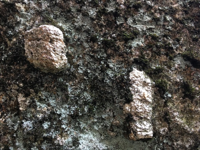
apparently these are potassium feldspar crystals
Three, maybe four, people left the hut in the same direction as me and I pass one and then wave to another a bit of a ways ahead of me, but otherwise I see no one else on the trail. The view is exhilarating and the rock formations fascinating and before I know it I’ve reached the top of Miyanouradake.
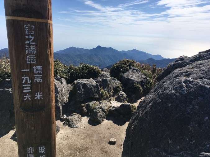
Miyanouradake: Kyushu’s highest peak at 1936 meters (6352 feet)
It’s 9 AM, so I’ve been hiking for almost 3 hours but it totally doesn’t feel that long even though it was uphill because it was so fun and my stoke level is super high. I have the peak all to myself. Not only do I have a 360 degree view to the sea on all sides, I can see the hazy line that is Tanegashima (種子島) on one side and a small more triangular shape of Kuchinoerabujima (口永良部島) on the other. I have a snack, some coffee, text Kiwi sig other that I am still alive and check the weather as cell reception comes in and out. Apparently, it’s supposed to start raining Thursday around noon, but the rain doesn’t look too bad, it’s not thunderstorms like on Monday. If it’s the last day of hiking, even if I get wet and cold I can warm up and clean up at an onsen at the end of the day. Hrm, still not sure where I’ll sleep tonight.
Then another hiker reaches the summit so I decide to head down to give him his own exhilarating top of the world moment. Going down from the summit the trail starts to get more and more wet and marshy, and I begin to see more people. Basic trail etiquette is that people climbing up have the right of way. As I step aside, I feel irrationally resentful of the people carrying daypacks to summit Mt. Miyanoura from Yodogo Trailhead since I somehow feel like I earned it more than them. I start to run into some mountain guides labeled by the ID tags hanging from plastic sleeves around their necks carrying very large packs and their group members carrying much smaller ones. I run into one such guide, smile, say “konnichiwa” and pull aside. He says, there are 30 people in our group, please go ahead where you can. I dodge through the crowd on the trail as if it’s Shinjuku Station. I think I whack a couple with my sleeping pad. WTF. Who hikes in a 30-person group? That would be my absolute nightmare.
View coming down off Miyaouradake. Note the famous Tofu-iwa (Tofu rock) on the right midground. I think it looks like a sliced mantou (饅頭 – Chinese plain white steamed bun).
Around noon, I drop my pack for the side trail to Kuromidake (黒味岳), where I again find solitude and enjoy having the summit all to myself. Coming down from Kuromidake, I run into 3 other folks. One is a gentleman from Morioka who stayed at Shin-Takazuka Hut the night before and we have a short chat about our plans for the day. (We had chatted about Morioka and Iwatesan yesterday because I’m also familiar with the area because I pass through quite a bit going back to my JET Program hometown in Akita.) I tell him about my dilemma about Ishizuka Hut versus Yodogo Hut and how checking the weather on Miyanouradake didn’t help me reach a conclusion.
Panorama from the top of Kuromidake
I’m taking a break on a wooden platform at Hananoego (花之江河) junction when I see the guy from Morioka again. This is the junction where I can go to either Ishizuka Hut or Yodogo Hut. “I haven’t decided yet,” I say. He says after he saw me he had a chat with a nice young man who is a grad student in Kagoshima and that guy said he climbed Tachudake yesterday and it should not be missed. So his new plan is to stay at Yodogo Hut, hike the forest road to Yakusugi Land and climb Tachudake (太忠岳) tomorrow. Interesting, I say, that is a full day hiking option out of Yodogo Hut I hadn’t thought of. If he doesn’t mind me possibly glomming onto his plan, I guess I will stay at Yodogo Hut.
A third hiker we know from Shin-Takazuka Hut emerges from the bush. “Where did you come from,” says my new dad from Morioka (turns out he has three daughters in their 30s), “I thought you left earlier than we did.” The third hiker says he’d been hanging out by some rock formations all day. He asks, “Did you see that group of 30 go by?” I say, “Yes. Ugh. Hiking in a group of 30 would be my absolute nightmare!” He tells us, “I overheard they will be staying at Shin-Takazuka Hut tonight. Weren’t we lucky!”
It’s about 1:30 PM when the other hiker and I push on as dad from Morioka lays down for a nap. Photos don’t do Hananoego justice, it looks like a landscaped Japanese garden with ponds enclosed by moss carpeted marsh, framed by wind scarred and shaped white yakusugi, surrounded by mountains dotted with ornamental granite boulders.
Hananoego, Japan’s southernmost alpine marsh
At 3:10 PM, I arrive at Yodogo Hut. Yodogo (I was corrected by another hiker who said in Yakushima dialect the word for river is pronounced “go”) is really pretty in the afternoon light. It’s shallow, clear as glass and tinted green from the foilage above it. I again claim a spot on the second floor of the hut, then steal a pair of slippers from the hut shoe cubby to use as camp shoes while I stick my socks and shoes in a patch of sun to dry. They are soaked from walking in water half the day. I’m snacking on Yodogo bridge, studying my map with my feet dangling over the water when another hiker points out two yakushima monkeys (smaller than normal Japanese macaques) grooming each other on a tree branch overhanging the river.
Over dinner, I listen in on the conversation between dad from Morioka and the other hiker from Shin-Takazuka Hut while sipping umeshu no oyuwari (hot plum wine), courtesy of my new dad from Morioka. Turns out they are both serious Hyakumeisan peak baggers pretty close to finishing. Dad from Morioka drove to Kagoshima all the way from Morioka. Yakushima is part of his trip to bag all the Hyakumeisan peaks in Kyushu, with the exception of Mt. Aso, the peak of which is still off-limits due to recent volcanic activity. The other hiker is now pretty much only missing Hokkaido. He tells a story of one time he went on a three day hike and got back to his car at the trailhead only to find he was trapped for three additional days because the forest road back to civilization had washed out. They exchange tips on how to modify your car for better shachuhaku (車中泊 — sleeping in your car) at the trailhead.
At 7 PM it’s hiker lights out. I haven’t seen any manmade structures all day except for trail, and even if there are the huts, there is no electricity. I wonder if I can see any stars. The thought seizes me. I crawl out of my sleeping bag and down the ladder, tiptoe past the other sleeping hikers and run out to Yodogo bridge. But with tomorrow’s cloud cover already coming in, I only see about the same number of stars I usually see in Tokyo.
Date: April 19 • Start: Shin-Takazuka Hut • End: Yodogo Hut • Distance hiked: 9.6 km Achievements Unlocked: first time multi-day hiking • bagged a Hyakumeisan
I’m up at 5:30 AM. Tent is still standing and all pegs are still in the ground. Not really wanting to risk the campsite toilet, I break camp and go to the parking area toilet to wash up. I head back toward town to the bus stop for an 8:15 bus to Shirataniunsuikyo, which is supposed to be the inspiration for the forest in Princess Mononoke. I hope to pick up breakfast on the way to the bus stop to replace the one I ate for dinner the night before, but everything is still closed. The supermarket doesn’t open until 9 AM and the Tourist Info Center and cafe is closed on Tuesdays (good thing it was open yesterday!). Finally, at 8 AM a tourist trap omiyage shop opens and I am able to purchase some bread and Jagariko for breakfast.
The bus gets me to the trail head at Shirataniunsuikyo just before 9 AM. I dutifully use the toilet (toilet opportunities are limited in the mountains on Yakushima and peeing and pooing in the bush is discouraged because of the fragile ecosystem — you are supposed to do all emergency business in wag bags), turn in my “tozan todoke” hiking registration, and pay the recommended 2000 yen donation to the park service for overnight park users.
The “Mononoke Princess forest” is full of the little kodama forest sprites you see in the movie.
Nah, it’s full of tourists stopping in the middle of the trail to take photos and messing with your hiking pace.
At 10:30 I reach the turn off for the side trail to Taiko-iwa. Another hiker has dropped his pack at the bottom of the trail so I put mine right next to his and start climbing up to Taiko-iwa carrying only my phone to take photos with. Taiko-iwa is an amazing lookout onto a river and river valley painted all shades of spring green and dotted with pink mountain sakura.
View from Taiko-iwa. Sorry the photo does not do justice to the view, the lighting started to get better later in the day.
By 11:30 I reach the Kusugawa Junction with the Arakawa Trail, which is the most popular trail to Jomon-sugi, the oldest and largest known Yakusugi cedar. Arakawa Trail is an old logging railroad track which makes for super easy walking, so instead of breaking for lunch I just snack as I cruise along.
railroad track trail
nice composting bio-toilet
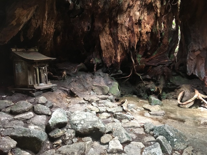
little shrine and spring inside the Wilson Stump
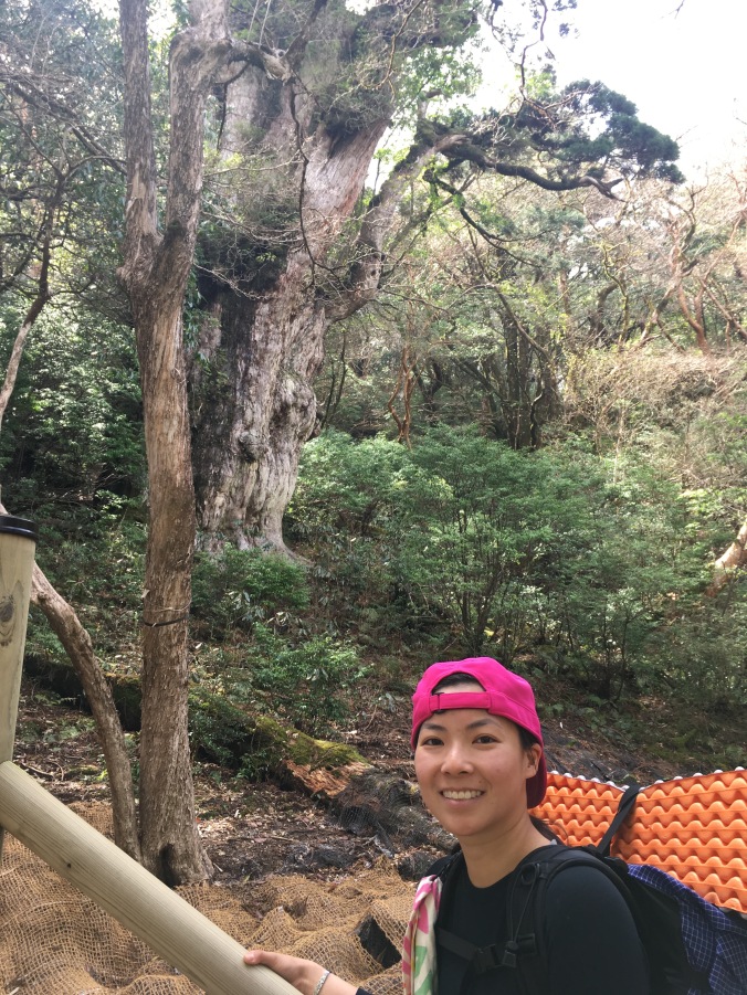
Past the Wilson Stump (a bit of interesting history about Wilson Stump here) the trail gets a bit harder and looks less travelled. I start to wonder if I’m going the right way because isn’t Jomon-sugi the most famous attraction on Yakushima? Then the trail starts to open up with some wooden platform resting areas and then north and south viewing platforms surrounding the famous Jomon-sugi. Later I would meet a 70-year-old man who would wax poetic about when you could walk right up and hug the Jomon-sugi.
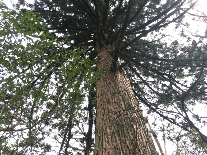
unnamed yakusugi
Jomon-sugi
I didn’t know how fast I would hike so I didn’t know if I would stay at Takazuka Hut just past Jomon-sugi or make it to Shin-Takazuka Hut. It’s only about 3 PM when I arrive at Takazuka Hut so I decide to press on for another hour to Shin-Takazuka Hut.
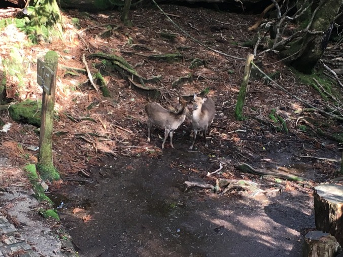
When I arrive at Shin-Takazuka Hut, there are two Yakushika deer hanging out in front by the sign for the toilet. I quietly slide open the door and poke my head inside. “There are two yakushika right outside the hut!” I whisper expectantly to a group of four older gentlemen heating up their dinner by the entrance. “We’ve seen countless yakushika today” one of them says and turns back to their dinner. No one is impressed and no one exits the hut to take a look.
yakushika hanging out by toilet sign (photo taken from my second floor window in the hut)
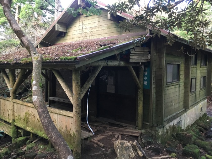
Shin-Takazuka Hut
It’s only 4 PM but everyone has already unfurled their bedrolls to claim a spot and has a Jetboils fired up to prepare dinner. Shin-Takazuka Hut has an occupancy of 60 people, but that would be in a survival situation with people packed in like sardines, each sleeping pad lined up right up against the next. I’m either the last or the second to last person to show up for the night. The second floor on one side of the hut is completely unoccupied so I climb up the ladder and unpack. I manage to change into a dry T-shirt and clean leggings under my sleeping bag. There are some ropes and hooks strung up inside the hut so I hang my sweaty hiking things up to dry. I had read that you have to hang your food inside the huts or it will get eaten by the cute little yakunezumi rats. I’m pretty sure the rat situation is not helped by everyone cooking in the hut. There is an exclamation downstairs (“Wow, that must be heavy!”) as someone whips out a real frying pan and starts to stir-fry something that smells mighty tasty.
The clouds had been clearing over the course of the day and it’s nice out so I set up my cooking station outside. One of the four older gentlemen that had been cooking near the entrance stops by on his way back from the toilet and asks when I came from today and where I plan to hike to tomorrow. Typical hiker conversation. After a few sentences exchanged he says, “You aren’t Japanese are you? That makes sense. A young Japanese woman wouldn’t go on a solo hike and stay at a mountain hut alone. Do you know Japanese ‘yama gal’? The ones with all the jangling bits hanging off of them.” *motions with hands* (The Japanese was 「チャラチャラしている」) “You can’t tell if they really like mountains or if they are just hiking to look cute.” Another old man in the group pipes up, “I don’t mind the yama gal. They add color to the mountains.” First guy continues, “You, you don’t look out of place at all. “ (「違和感ない。」) Thanks?
Turns out the four are all 70-years-old and part of a hiking group out of Tokyo. They have come from the opposite direction as me and summited Miyanouradake that day. I ask them to invite me along on some future hikes and we exchange contact info.
dinner!
There is one other solo woman hiker staying in the hut but besides me, everyone seems to be of retirement age. After dinner, it’s not even dark yet but everyone zips into their sleeping bags, so I do the same. Hiker lights out is 7 PM and I think I manage to fall asleep by 8 PM.
Date: April 18 • Start: Shirataniunsuikyo • End: Shin-Takazuka Hut • Distance hiked: 10.7km Achievements Unlocked: first time solo-hiking • first time cooking on a canister stove • first time staying in a mountain hut
[First in a series of posts about my adventure in Yakushima. It’s come to the point where I think if I wait until I finish writing up everything to upload anything, it’ll never happen.]
I arrive at the jet boat terminal just before 7 AM to try to catch the 7:45 AM jetfoil to Yakushima. By the time I reach the ticket window, the 7:45 is sold out so I get a ticket for the one at 12 noon.
Good thing the hostel I stayed at is less than 5 minutes away from the ferry terminal and I don’t have to check out until noon. I walk back to the hostel, pull my sheets out of the sheet disposal bin, climb back into my capsule and nap for 3 hours.
I arrive at Miyanoura port around 2 PM and make my way to the Visitor’s Center. The Visitor’s Center has free wifi and I sit at a table to pour over my map and newly procured bus schedule. Wifi at the hostel in Kagoshima had been iffy and I hadn’t been able to find an up to date bus schedule online in advance. I meet a couple carrying hiking gear and they ask me where I plan to hike, I say I plan to start at Shirataniunsuikyo and head around to Jomon-sugi and then Mt. Miyanoura. They say they plan to do about the same. I ask if they are starting their hike tomorrow morning. They say, no, they are starting now. They leave to catch the 3:30 PM bus to Shirataniunsuikyo.
last minute trip planning
I briefly contemplate joining them. But heck, I brought my tent and in Kagoshima I only picked up hiking food for 3 days. I decide to go set up my tent and then come back to town in search of hot dinner.
Miyanoura town
Google Map is not helpful in finding the municipal run Ocean View Campsite. I walk around in a big circle and finally see a small and faded sign for the turn off to the campsite by a seaside rest area toilet. At the entrance to the campsite is a sign that says “No unauthorized camping. Please register at the tourist information center.” Well, it took me 40 minutes to find this place and I’m not walking back to the tourist info center now as it starts to rain. I circle around the campsite. There is no one there. There is a toilet and some sinks with taps and running water, an old house probably for the overseer and some beehives.
I find a spot sheltered from the wind coming off the sea behind some bushes that looks nice and flat. The rain starts to pick up, so I throw down my sleeping mat and empty out the contents of my pack on to it. My tent is packed at the very bottom of my pack as suggested by some backpack packing diagram on the interwebs. Very smart and practical. (Will def need to rethink this.)
Good thing I practiced setting up my tent in Yoyogi Park once before this trip. I hastily stake my tent down, lever it up with a hiking pole and throw all my stuff inside as it really starts to thunder storm. Now what? I am regretting not having brought my Kindle. It’s about 5 PM.
After a while, I Google how to set up a tarp guyline and teach myself the bowline knot and tautline hitch. Then I throw on my rain jacket and set up a an additional tie out on one side of my tent to give me a bit more headroom in the stormy conditions. I tension up my tent a bit but give up on the prospect of going to town for dinner. I cannibalize a breakfast and turn in for bed around 8 PM.
The rain hitting my tent sounds like a million crinkling potato chip bags. Around midnight, the rain lets up a bit and the wind picks instead. The silnylon of my tent billows so much that I think my extra guyline must’ve given out, but it’s not slapping my face or anything so I’m too lazy to fix it. Sometime in the night, car headlights beam through the bushes and a group of car campers bustles around briefly, setting up camp in the rain. I don’t see think they see me, and by the time I wake up the next morning, they are gone.
Date: April 17 • Start: Kagoshima • End: Miyanoura • Distance hiked: 0 km Achievements Unlocked: first time stealth camping • successfully pitching tent in the rain • learned to tie some knots