JMT 2019 Day 7: Zero Day at VVR

September 10, 2019
Moseying about VVR
Day miles: 0 mi
Cumulative miles: 66.7

On my zero day at Vermilion Valley Resort, I didn’t even journal. (I took some notes the next day when I got back on trail.) A “zero day” is hiker lingo from a day where you hike zero miles. I had actually planned to take a “nero”, a day where you hike nearly zero miles, but was ahead of schedule.

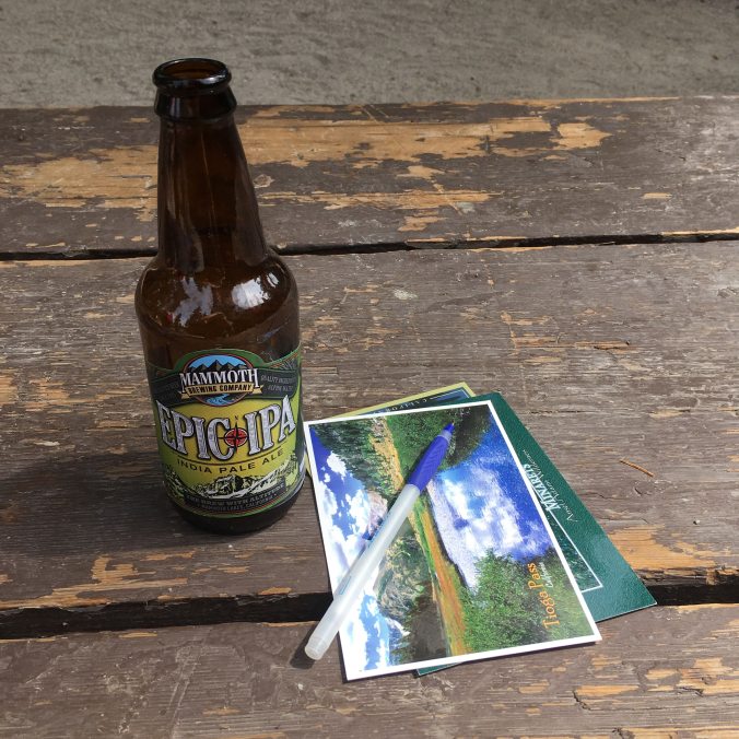
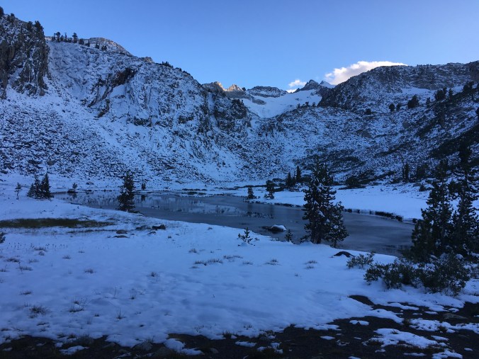
It was wonderful to wake up, not have to pack up and just wander over to the main building, and order hot breakfast. I think I got both the classic bacon, eggs and pancakes and a breakfast sandwich. I had been craving savory breakfast. The pancakes were the best! Then, I got a shower and did my laundry. I fetched my resupply and packed my food for the next section of trail. I hung out at a picnic table, drank a beer, ate a bag of potato chips, and chatted with other hikers. There was a good mix of PCT hikers, JMT hikers and veteran Sierra hikers hiking loops they’d made up themselves. I pet sat a wonderful trail pup named Darwin when his mom went to take a shower. I took a nap. There is no wifi at VVR (though you can pay to use one of their computers), so I walked out onto the dam for AT&T cell reception and texted friends and family that everything was well. I did some yoga on the beach. I ate a giant fried chicken sandwich for dinner. All these mundane little things felt like absolute luxury. It was a perfect day. (Except I got stung by a bee, more on that later.)

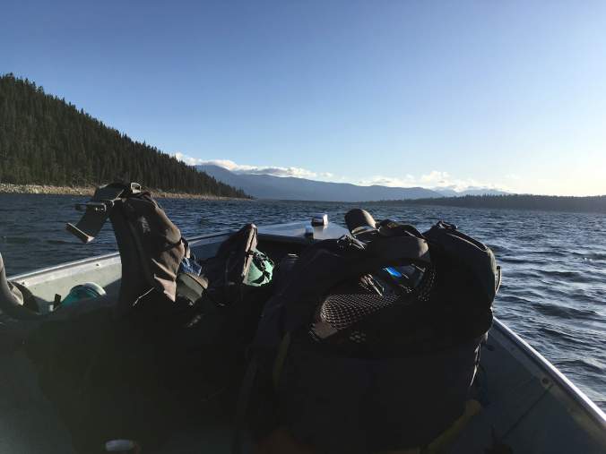
This vortex of two nights and a day at VVR, including paying for my resupply pick-up and taking the ferry both ways cost me $195 and I tipped them $40. The VVR crew was excellent and it was an amazing hiker-friendly experience. Highly recommend resupplying and taking a zero at VVR!

IMG_4570

Contemplated helping in the kitchen… but then decided I really just wanted to luxuriate in doing nothing. There already were resupply chores to be done.

IMG_4571

IMG_4559

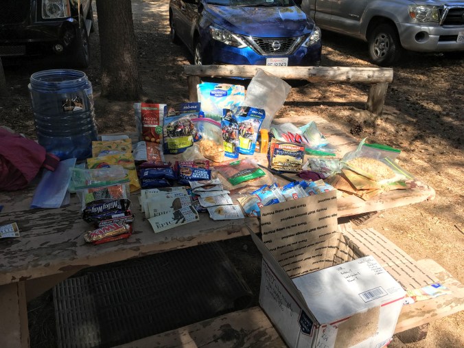
Sorting through my resupply. What do I want to eat? What do I not want to eat? A theme for my hike is I have packed too much food. I leave all my oatmeal and a bag of peanut M&Ms in the hiker boxes.

IMG_4562

Food for 7 days packed in my bear can and the first days’ food set aside to be packed at the top of my pack. 8 days till my next resupply in Independence!

IMG_4568

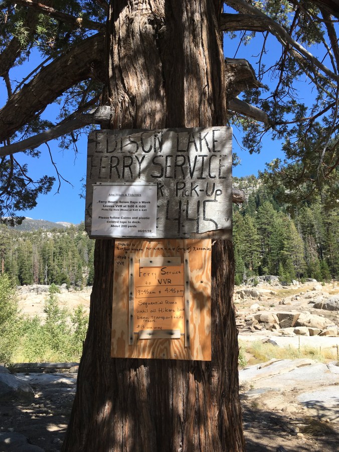
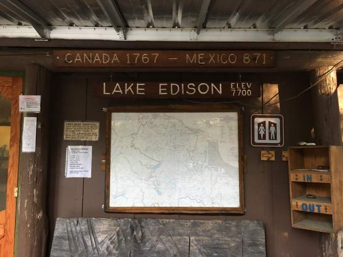
Wandering out onto the dam for cell service. Lake Edison was formed by Vermilion Valley Dam in 1954, is named after Thomas Edison and owned by Southern California Edison, the power company.

JMT 2019 Day 6: Silver Pass

September 9, 2019
Squaw Lake to Vermilion Valley Resort (9.5 miles)

After the long hiking day yesterday, I thought I might sleep in. But I woke up at 4:30 am, realizing that if you go to bed at 8:30 pm, by 4:30 you have probably had a solid 8 hours of sleep. I got up for a pee, fetched my bear can and boiled water for coffee while packing up things in my tent. I ate my breakfast of Probar & coffee sitting on the granite table next to my tent, with my feet dangling in my quilt foot box and the quilt buttoned up behind me, looking like some sort of mermaid, except half-human, half-fat caterpillar.

IMG_4474

Bag packed and leaned up against the granite “table” at my campsite

It’s a bit warmer than the previous morning, but there are still thin clear sheets of ice along the shores of Squaw Lake and Chief Lake when I begin hiking. I start hiking at about 7:45 and reach Chief Lake in about an hour and a half, just as the sun comes rising over Chief Lake. I find some nice flat slabs of granite, roll out my Thinlight pad and do some sun salutation into the sun. I decide I should make this a routine, hike until warmed up and then stop to do yoga and stretch.

IMG_4477

View from my yoga spot on the banks of Chief Lake

IMG_4479

At the top of Silver Pass I meet a PCT thru-hiker from Belgium named Weatherman, and we take some pictures of each other. Descending the south side of Silver Pass, the landscape is very reminiscent of the Gallatin and Madison Ranges in Montana (where I had done all my training hikes in the summer), only without the moose and grizzlies. Then the trail follows Silver Creek down into the forest flanked by smooth granite formations like those in Yosemite.

IMG_4481

Silver Pass

IMG_4530

Hello, southwestern Montana! (Actually, basin south of Silver Pass)

Mid-morning, I stop and take break where the stream runs over bare granite and ice my feet in an indentation in the rock that makes a perfect little footbath. The water is painfully cold. I eat salami wrapped in a tortilla.

Then it’s down, down, down an endless set of rocky switchbacks. At one of the stream crossings, I meet a couple with the best hiking pups ever, each carrying its own backpack and following faithfully right behind the heels of their owners. I stalk closely behind this group because the sight makes me so happy until we part ways at Mono Pass junction. (Between Yosemite and Kings Canyon/Sequoia National Parks is the dog friendly portion of the JMT and it was always a treat to meet people’s furry friends on the trail.)

IMG_4542

I reach Ediza Lake junction by 2 pm, so I decide to take the 4:45pm Edison Lake ferry to Vermilion Valley Resort (VVR) half a day earlier than planned. I meet some folks already waiting for the ferry by the bear box around 2:35. They mosey down to the ferry dock while I spread out my tent and ground sheet to dry in the sun. The sun out by the ferry dock is harsh, so I roll out my foam pad to nap in the shade of the trees by the bear box.

IMG_4554

IMG_4552

Lake Edison ferry dock

I am laying prone on my mat using my freshly dried tent as a pillow when Ellen rolls up. We catch up. She’s been having trouble with the cold due to old frostbite injury and managed to lose one of her two pairs of shorts and hasn’t been able to swap out her outfits as she normally likes to do. I tell her I saw her shorts at Red’s Meadow and was hoping I would see her there and I am super glad to see her again going into VVR.

Around 3:50, Ellen and a section hiker we have been chatting with head over to the ferry dock. I am rolling up my foam pad and putting my hiking boots back on when another familiar face appears, it’s Larry! He made it from Red’s in less than two days, camping last night at Lake Virginia. It turns out that the usual ferry is out of commission, so the boat captain has to make multiple trips across the lake in a little skiff and can only take 5 people at a time. My dilly-dallying in the shade puts me on the third and last boat, so Larry, another hiker and I share our life stories as we wait for our ride.

IMG_4555

Putting 5 hikers and their gear in this little boat is pretty sketchy…

We finally arrive at VVR when it is starting to get dark. We get the spiel, get our tabs set up, go set up camp (JMT and PCT hikers get two nights free camping and a free beer at VVR) and I eat a steak dinner. Showering will have to wait till tomorrow.

IMG_4556

The boat ride to VVR was a bit more thrilling than anticipated…

JMT 2019 Day 5: Hidden Gems

September 8, 2019
Deer Creek to Squaw Lake (15 mi)

It’s a frosty morning. Sitting in my sleeping bag poking at my oatmeal, I come up with a theory that the reason it takes me so long to get out of camp every morning is I don’t really want to eat my oatmeal. I wake up around 6 but can’t seem to get on the trail until 8. I wish I had savory breakfast, that I had packed something like cheesy grits with bacon bits. I have never had issues with oatmeal before, but I decide to experiment with eating Clif bars for breakfast the next couple of days and see if that speeds up my morning routine.

There is a 5 mile dry stretch between Deer Creek and Duck Lake, one of the longest dry stretches on the JMT, so I start the day carrying just over 2 liters of water. I see a sooty grouse as big as a chicken and then some cute California quail with their little bobbing head plumes, twittering and running about in the manzanita. Too bad Dan and Dakota aren’t here to get them for me for my dinner and I’ll have to eat a dusty looking ziplock of Mountain House instead.

IMG_4437

I take my lunch break at Purple Lake, then head on to impressive Virginia Lake. Virginia Lake is as clear and blue as Lake Towada (caldera lake in Japan famous for its bright blue color, which is the pride of the small town where I lived for two years after college). I would have and should have swam in Virginia Lake, except I was still relatively clean from yesterday’s shower.

IMG_4442

Purple Lake

IMG_4448

The trail skirting beautiful Virginia Lake

From Lake Virginia, the trail descends to the headwaters of Fish Creek, which was true to its name, full of small mountain trout until the river began to descend steeply in rapids and waterfalls. There were a few nice campsites along Fish Creek and I thought about how if you planned to fish along the trail you would plan a different itinerary and camp at Minaret Creek and Fish Creek, etc. instead of the high alpine lakes I have a preference for.

IMG_4457

Fish Creek

IMG_4459

Bridge across Fish Creek

After crossing Fish Creek over a nice steel bridge, it’s a slogging climb up towards Silver Pass. Squaw Lake sits hidden atop a shelf and when you finally step up there, it feels like a magical secret world.

IMG_4466

Squaw Lake is hidden up there!

IMG_4467

View from the top of the climb

IMG_4468

Squaw Lake from my campsite in golden afternoon light

My tent site is a gravelly patch behind some stunted pines. It is not quite flat, but I will tuck my backpack under my sleeping pad to help level the floor. 15 miles is the longest distance I have hiked in a day so far, and I am looking forward to having a short 8 mile day tomorrow where I can fully enjoy Silver Pass and its lakes.

JMT 2019 Day 4: Trail Magic

September 7, 2019

Trinity Lakes to Deer Creek (12.6 mi)

I manage to rock hop across Minaret Creek without getting my feet wet. The creek crossing is at a peaceful little bend where cute little trout appear suspended in place where the current is mellow over smooth rock. (Trout on the JMT are non-native and have decimated native amphibian populations. More info here.) Shimmying between two trees on the other side of the river, I find a package of Backpacker Pantry Pesto Pasta with (real Alaskan) Smoked Salmon and a Pro Bar, that must’ve fallen from someone else’s pack when they did the same shimmy. I decide I can’t just leave food on the trail, because bears (duh!), and this stuff is fancier than the food I packed, so I pack it up with the intention of swapping it out with a couple of my meals at Red’s Meadow. Trail magic!

The descent into Red’s passes through an area where a crazy windstorm uprooted massive trees in 2011. The gnarled root bases of some of the blown-over trees are twice as tall as me. It would’ve been absolutely terrifying to be on the trail when the trees were toppling. The trail is pumice sand, soft on the feet, and, since it descends in elevation, nicely shaded by forest.

IMG_4412

Blow-downs

IMG_4415

View of Devil’s Postpile from across the valley. Jackie and I detoured over there in 2017.

IMG_4418

Sierra gooseberries, which Lizzy Wenk said I would see on this section of the trail. On trail, the incredible detail of the Wenk JMT guidebook really enhanced my experience in little moments like these. The berries are edible and I did try a couple. The berries are like tiny passionfruit when you burst the spiny shells open.

I arrive at Red’s Meadow around noon. First, I go find the hiker boxes, which are in one of the bear boxes at the campground. I drop off my extra food and score some soap, shampoo and conditioner. There was some good stuff in the hiker boxes, including a brand new Sea to Summit SOL emergency bivy, which I seriously consider taking. (Totally didn’t need to for the JMT, but would like to add one of those to my winter ski touring pack.) Then, I went to the store to get shower tokens. You have to get a minimum of 5 $1 tokens for 5 minutes to start the shower machine. So, I got 10. I stripped down in the shower and washed all the clothes I was wearing, except my pants. Wet everything down and soaped up during the first 5 minutes of shower. When the shower stopped, I took my time and scrubbed everything thoroughly before rinsing off in the second 5 minutes of shower. I put on my extra hiking t-shirt and hung my wet clothes on the deck outside the shower building, next to what looked like Ellen’s red shorts.

I looked around for Ellen but didn’t find her; instead, I found Larry getting into a car with his wife to go into Mammoth. Ellen and Larry had both stayed at Red’s the night before, and Ellen was back on the trail. I went to the Mule House Cafe, got the weather forecast and ate a cheeseburger with Endless (who I had met down by the hiker boxes) and his PCT trail family. Then, I went back to the store and bought a beer and some postcards. Finally, I went and collected my mostly dry clothes from the shower building. I meant to leave Red’s by 2 but ended up staying until 3 because any stop into civilization turns into a vortex! However, it was worth it because I stayed long enough to poop in a real flushing toilet!

IMG_4426

Comforts of civilization

The trail south of Red’s climbs up through a hot shadeless burn, which is annoying because I don’t want to sweat because I am freshly showered. When I get to Deer Creek, which is a very popular camping area, Kathryn and David, who I’ve seen a few times on the trail, wave me over to join them at their campsite and I accept. I intend to be more social in the evening, but there are so many mosquitoes, I just eat my dinner and retreat into the safety of my tent.

IMG_4429

Even the supposedly not-so-scenic parts of the JMT are incredibly scenic.

JMT 2019 Day 3: Alone on the JMT

September 6, 2019
Thousand Island Lakes to Trinity Lakes (9.4 mi)

I wake up to my watch alarm at 6:15 and after a couple snoozes get up to witness the morning light show on Banner Peak, still shrouded in cloud as it was in the evening.

IMG_4391

I manage to leave camp even later than yesterday, even though I did not poop before packing up! (#thousandislandlakeproblems) Part of this is because I am only able to start my day after packing and unpacking and repacking everything in a panic, thinking I’d broken my only hair rubber band and not being able to find a replacement. I have to fish the snapped hair rubber band out of my garbage ziplock and tie it back together. (Later in the evening I will find my spare hair rubber bands in my electronics bag…. not with toiletries or first aid where I looked.)

I reach Garnet Lake at 9:30 am and take my first break for the day, then break for lunch around noon at Shadow Lake. I climb the Shadow Lake switchbacks with Don and Mike (who I distinguish by the fact that Don is carrying two solar panels, and Mike, one) who make it much more bearable.

IMG_4392

Garnet Lake

IMG_4403

IMG_4402

IMG_4408

Shadow Lake


I look for familiar faces at Rosalie Lake, and not finding anyone, continue on the Trinity Lakes and set up camp around 4 pm.  Most of my trail friends are headed to Red’s Meadow for the night. I didn’t plan to stop at Red’s and Trinity Lakes is the last established campsite in the Wenk book before Red’s Meadow. According to the book, you have to hike 4 miles past Red’s for a decent campsite. Trinity Lakes are three little marshy ponds. My tent site is nice and wide open; it’s easy to stake tent stakes into the ground. But it’s relatively hard to gather water that’s pretty stagnant and a tiny, tiny bit murky, less than ideal for the JMT, where clear water flows over granite most of the time.

Waiting for your food to rehydrate is when some company would be nice. Otherwise, it is nice to be camped alone after 3 nights at popular campsites. The Guthook app suggests that I may have cell phone reception in this area, and indeed I am able to post a couple photos to Instagram. I do a bear can inventory which confirms I have a too much food. I have not been hungry on the trail so far and it is the idea of lightening my pack that motivates me to eat. I decide to stop by Red’s Meadow and drop off some stuff… and find myself very much looking forward to having a burger for lunch!

JMT 2019 Day 2: My Hiking Superpower

September 5, 2019
Upper Lyell Base Camp to Thousand Island Lake (8.6 mi)

IMG_4381

There is a break in the clouds and warm sunshine to bask in when I reach the outlet of Thousand Island Lake around 3 pm. I filter some water and and relax on the lake shore contemplating whether to camp here or continue on. I have been leapfrogging with Larry and Ellen all day, and they have been trying to convince me to hike a bit further than planned and camp at Garnet Lake instead of Thousand Island Lake, which Larry pish-poshed as “Thousand Camper Lake.” It is still early, but storm clouds have been threatening since I crested Donohue Pass at 9:25 am.

IMG_4369

View from Donohue Pass

It hadn’t rained yet despite the ominous dark clouds and I had bragged to Larry and Ellen over lunch about my ability to make it not rain on backpacking trips. Larry exclaims, “You’re not supposed to talk about such things!” Ellen pipes up that she never filters or treats her water and she has never gotten giardia. Larry is aghast that we would so nonchalantly curse ourselves.

IMG_4375

Heading toward the dark, volcanic Ritter Range

When I finally decide I will stop hiking for the day and camp at Thousand Island Lake after all, the clouds close in and the temperature drops. I put my fleece back on.

Larry is not wrong, Thousand Island Lake is a super popular place to camp. The nice sandy campsites Jackie and I occupied two years earlier are already taken, and I walk further around the lake away from the other people and pick an exposed, rocky spot for the view as a light rain begins to fall. I retreat into my tent planning to nap, and of course the sun comes out and turns my tent into a sauna. Banner Peak is shrouded in a cloud, but as the clouds blow across the lake towards me, the sun appears to burn them off. Make up your mind, clouds! I just want to nap! Then, it suddenly starts to rain in large droplets that pummel the ground with such intensity that they spray sand all over everything. It rains so hard that water bounces under the vestibule of my tent and I have to stuff my sleeping bag back into my drybag/packliner to keep it from getting wet. Rain is followed by a bit of hail.

It cools down and I am lying comfortably in my tent when there is a commotion outside as what sounds like a group of 10 weekend backpackers from the city contemplate setting up camp right behind me. There is not enough room for all of their tents, thankfully, and they move on. And so, it turns out to be a good decision to camp at Thousand Island Lake instead of hiking through intense downpour and hail to Garnet Lake.

IMG_4383

Cons of Camping at Thousand Island Lake:
This is the hardest place on the JMT to find a good place to poop. There probably are a thousand campers at Thousand Island Lake every summer. It’s part of a beautiful backpacking loop from the Mammoth Lakes area. Behind every tree on the slope north of the lake near the campsites is some sign that a cathole has recently been dug. Or worse. Thousand Island Lake seems to be a place where a lot of beginner backpackers camp and I saw travesties like a bunch of rock piled on top of naked poop and toilet paper. Thousand Island Lake really needs a toilet because it is so popular. Some Silicon Valley tech billionaire should endow a pit toilet, like the public restroom in Bryant Park in NYC. (Bay Area friends, write your friends.)

Pros of Camping at Thousand Island Lake:
The view. Memorialized and made famous by Ansel Adams. You can only to fully enjoy the view and its infinite changes at sunset and sunrise if you camp here.

IMG_4388

6:32 AM

IMG_4391

6:37 AM


Video: How to JMT | How to Pack a Backpack

As COVID-19 skill building, I made a YouTube video! In the first of a series of videos I imagined while hiking the JMT, I present “How to JMT: Pack a Backpack”:

Future topics may include how to:

  • dig a cathole
  • prevent blisters
  • use your pack to level an uneven sleeping spot

You can read more about the gear I used on the JMT and my gear philosophy (totally not fussed) at this previous blog post.


JMT 2019 Day 1: Return to Upper Lyell Base Camp

IMG_4343

September 4, 2019
Tuolumne Meadows to Upper Lyell Basecamp (11 mi)

I set off from the Tuolumne Meadows backpacker campground around 7 am, foregoing hot breakfast at Tuolumne Meadows Grill which doesn’t open until 8 am. Lyell Canyon is gorgeous of course, with the river running over bare granite and open meadows just starting to yellow for fall. The forecast posted at the the general store said thunderstorms after 11 am, so I want to get as far as I can by then.


The trail up Lyell Canyon, a classic U-shaped glacial valley, is pretty flat. My pack, loaded with 7 days of food, is manageable but not comfortable. Every hour or so my shoulders start to cramp up. But if I take a short break I quickly recover and am able to keep going again. It hails a bit, but when I finally pull over and duck under a tree to put on my rain jacket, it stops. And that is the function of rain jackets, e.g. if you don’t bring one, it will definitely rain.

IMG_4351

After a leisurely 300 feet of elevation gain over almost 10 miles, suddenly you reach The Wall, and begin to climb what feels like straight up out of the valley. I leap frog with a couple other solo lady hikers and reach my intended campsite at Upper Lyell base camp just before 3 pm. I could have hiked farther but I don’t think I want to continue on up Donohue Pass before eating some more of my food (and lightening my pack)!

This is the same campsite Jackie and I camped at in 2017. This time it is warm and pleasant instead of deathly cold. The bad thing is mosquitos definitely gather when the wind dies down. Good thing the location tends to be very windy from the katabatic winds coming down from the pass. When I camped here in 2017, the wind snatched the gray stuff sack for my tent when I unpacked. Blown into a landscape of gray granite, the stuff sack was lost forever. Since that day, I have preferred bright colors for my outdoor gear.

After setting up camp, I roll out my Thinlight foam pad to do some yoga and promptly roll my right ankle on a tuft of grass. First day of my hike and of course I injure myself when I’m not even hiking!

I am sitting on a rock in the breeze writing in my journal when Larry rolls up, followed soon after by Ellen, both also hiking solo. These are my campsite mates for the night and we have dinner together. Larry is talkative, wears bright compression socks and works for one of the big four accounting firms. Ellen is a former athlete with a career in sports medicine. In her 60’s and having sustained injuries and worn out her body over the years, she hikes completely hunched over her trekking poles in jerky movements, overcoming pain with pure tenacity. She’s an experienced mountaineer, warm and funny, packs a handle of whiskey and is a total bad ass.

IMG_4359

View of Donohue Pass from my campsite.

2017 Upper Lyell Basecamp

Same exact view September 23, 2017. The small lake is actively freezing over after the sun dropped down behind the mountains to the west.


JMT 2019 T minus 1: Lone Pine to Tuolumne Meadows

September 3, 2019

IMG_4322

I catch the 6:15 am ESTA bus from the Lone Pine MacDonald’s, which is full of backpackers repacking their packs at 6 am. I have left my car in the overflow parking of the Historic Dow Motel, which provides long-term parking to its guests. (Another place you can park while you hike for a small fee is the Museum of Western Film History.) I chat with my seatmate who has just completed the entire JMT in ten 25-30 mile days, waking up every morning at 4:30am. He says it was a sufferfest and he wishes he had gone slower so he could remember more parts of it. Most of the other folks on the bus have just finished the JMT or other hikes in the Sierra and are heading north to Reno to fly out to wherever they are from, including England and Australia. I am dropped off with one other hiker at Tioga Gas Mart at the turn off for Tioga Pass to catch the YARTS bus into Yosemite. (This is not an official ESTA stop on their website but when you make a phone reservation — which is advisable because the bus I was on was full — and tell them you are transferring to YARTS, ESTA will stop at the YARTS stop.) I feel nostalgic as I walk into the gas mart to use the restrooms. Last time I was here, I was miserable at the prospect of not being able to finish the trail.

The YARTS bus drops me off at Tuolumne Meadows just after 10 am. The Tuolumne Meadows store and campground feel like familiar ground. I go and stake out a campsite in the backpacker campground, setting up my tent and stashing my food in a bear box. Pack lightened, I hike over to the wilderness center to pick up my permit.

img_4324

They give you a wag bag for Mt. Whitney when you pick up your JMT permit. I dutifully carried it to Red’s Meadow and dropped it in the hiker box with all the others. Then I picked one up from the hiker buckets at Mt. Williamson Motel in Independence. Should have just left the first one at Tuolumne Meadows.

I make a loop around Tuolumne Meadows, covering the two miles we skipped last time to hitchhike to the post office before it closed. I visit Parsons Lodge and listen in on some ranger talks, learning about habitat restoration in the delicate alpine meadows and the importance of not going off trail. I take a taste of Soda Springs and walk towards Lembert Dome. An ominous cloud builds up over the mountains to the south, and I abort the idea of climbing Lembert Dome to go hide in my tent.

IMG_4335

Yay! Back on the trail!

img_4340

Lembert Dome

It thunders and hails but doesn’t rain much. When I set up my tent in the morning, mine is one of two or three tents set up in the backpackers’ campground. When I emerge in the afternoon, it is full, with excited hikers happily welcoming late comers to share campsites. In the evening, folks stroll around the backpackers’ campground, beer in hand, in a home and garden tour of the most popular backpacking tents on the market. A young European couple is in some kind of cuben fiber (oh, I’m sorry, DCF) spaceship that we all ooh and aw over.

There is a campfire talk in the evening about glaciers and the Q&A inevitably turns political. It’s a pleasant surprise and comforting that the NPS is still allowed to talk about climate change as a fact, though of course the ranger is mostly preaching to the choir. It ends with a super awkward rap with a refrain that she makes us sing along: “ice, ice, baby…. melting.”

*** ***

Looking back at my journal to write these posts, I noted between the entries for September 2 and September 3 simply:

Sunrise 6:23 AM
Sunset 7:16 PM

This was from the weather app on my phone so I would have an an idea of how long I had each day to hike. I knew I would lose cell reception after Lee Vining. Cell reception on the JMT is very limited. Tuolumne Meadows has Verizon, but at the time I was on an AT&T based carrier. When I left for the trail, friends said things like “Looking forward to reading your blog posts from the trail!” and I didn’t have the heart to tell them I wouldn’t actually be able to blog from the trail. I will randomly find great reception at a campsite near Trinity Lakes and post a couple photos to Instagram, and when I get to VVR, I will walk out onto the dam to text my emergency contact that I am on schedule. There is cell reception at the top of Kearsarge Pass which I will use to call and leave a message with Mt. Williamson Motel that I am on my way and that I want to take a zero and stay an additional night. That’s it. I didn’t carry any kind of satellite emergency communication device, but I met a lot of people who did. If I saw someone with a Garmin InReach hanging from their backpack shoulder strap, I would sometimes ask if they had the weather forecast. Not being connected is one of the best things about backpacking and going deep into the wilderness. I suspect it’s why I’m only able journal consistently out there.

JMT 2019 T minus 2: From the Rockies to the Sierra

September 2, 2019

I tried to listen to An Indigenous People’s History of the United States while driving across the Great Basin, because you can’t help but see how inhospitable it is and the presence of reservations, casinos and brothels evince a certain history… but the history is too sad and enraging. Instead, I listen to American Wolf and think fondly of the Greater Yellowstone Ecosystem that I’ve been privileged to live in and will be going back to.
I am driving over 1000 miles from Big Sky to Lone Pine, from the Rockies to the Sierra over dry and desolate shrublands, so sparsely populated. It’s the kind of landscape that makes you worry about whether you are going to make it to the next gas station and where the marks of capitalism and globalization, bright highway signs of McDonald’s and Chevron, simply feel welcoming and comforting and familiar.

I camp at Carlin Canyon in my car, with the windows open a crack and it is comfortable and I sleep well from 10pm to 6am. I wake up, duck behind a bush for a pee, make some coffee on my backpacking stove and am on my way. I stop at the next rest stop to poop and pick up a hitchhiker holding a gas can and take her to the next gas station. 

I drive until I am tired and hungry but not hungry for any of the food I have. I pull over for a rest but it’s too hot to turn off the AC. There is no shade, just desert-y hills for hundreds of miles. 

Finally, I cross the border into California and the Owens Valley. I contemplate detouring to Lee Vining, which I remember fondly from my 2017 JMT thru-hike attempt. But is it out of the way, and I will pass through it tomorrow. As I drive south toward Bishop I can barely see the Sierra due to smoke from nearby fires. At the Vons in Bishop, I get wifi and inquire on the Ladies of the JMT Facebook group and am assured that the current fire situation will not have an impact on my hike. 

It starts raining as I leave Bishop. The rain washes the smoke from the valley air and reveals the peaks of the Eastern Sierra, looking harsh and intimidating shrouded in storm. At Lone Pine, Highway 395 is at less than 4000 feet. Mt. Whitney tops out at 14505 feet. It’s going to be a big descent at the end of the trail. And I am going to have to climb down to the Owens Valley and back up to the Sierra crest for my resupply in Independence.