The Shinetsu Trail is an 80 kilometer trail from Mt. Madarao to Mt. Amamizu along the ridge that separates Nagano and Niigata prefectures. I found out about it while hanging around Iiyama Station waiting for a Shinkansen when I was living in Nozawa Onsen. In Japan, it’s a rare “long trail” designed for multi-day trekking and not peak-bagging. It is not high elevation (the tallest peak is Mt. Madarao at 1382 meters) and there is not very much elevation change. There are no Hyakumeisan and no fancy mountain huts along the trail. Instead, the trail crosses many historic mountain passes between Nagano and Niigata, used for trade and travel between the domains of Shinshu and Echigo once upon a time, some of which have now become roads which provide easy access to various points of the trail. Some local minshuku down in Iiyama valley are signed up to provide accommodation for hikers on the Shinetsu Trail and will drive you to and from the appropriate trail heads each day. Or there are six designated tent sites along the trail. Four are barebones sites with pit toilets and a water source maintained by the Shinetsu Trail Club, an NPO, and two are existing commercial camp facilities.
Since my interest in the Shinetsu Trail was to use it as a practice hike for the JMT, I planned the hike as a 5 day 4 night tent camping (“tento-paku” in Japanese) backpacking trip and my friend Genna from Nozawa hopped along.
This is the story of how it went down.
Day 1 — Monday, June 19
Course: Chiroru Trailhead (チロル登山口) → Mt. Madarao (斑尾山) (start of Shinetsu Trail) → Akaike (赤池)
Distance: 11 km
Genna and I catch the Hakutaka 553 Hokuriku Shinkansen departing Tokyo 7:52 and arriving in Iiyama at 9:43. I had planned for us to catch a 10 AM bus from Iiyama Station to Madarao Kogen Hotel to start the hike. But, when we arrive at the bus stop in Iiyama, it turns out that the 10 AM bus only runs on weekends and holidays. Rookie mistake. So, we get a ride from a concerned taxi driver who warns us about mama bears with their cubs.
Since we take a cab, we are able to get the driver to drive us all the way to Chiroru trailhead (where the main lift ticket office is for Madarao ski resort in the winter). The climb up Mt. Madarao is basically straight up the ski slope, steep and hot, with no cover and, frankly, not very fun.

I climbed the last bit to the peak from the top of the highest chair lift twice last winter for a backcountry tour. I thought it would be interesting to see what the mountain looked like in the summer. Everything looked totally different. The last time I was up there we hiked to the right of a huge cornice.

Hiking up Mt. Madarao in February
Last winter, our guide Andy from North Nagano Outdoor Sports had explained that the snowpack on Mt. Madarao is very stable because the short bamboo (sasa) covering the mountain creates a great bonding layer for the snow. There were many bamboo shoots poking out on the hiking path but nothing tender enough to pick and eat.
At the fork right before the peak, we run into two sprightly young guys (college students?) with sleeping pads strapped to the outside of their packs. We run into them again loitering around the signboard at Akaike when we finish our first day’s hike around 4 in the afternoon. The boys pressed on and I found out from Instagram later that they thru-hiked the whole trail in 3 days and 2 nights.
It is an easy hiking day. We get to the top of Mt. Madarao to begin the trail just before 11:30 AM and reach our campsite at Akaike before 4 PM. We hike through beech (buna) and cedar (sugi) forests and couple small marshes, one full of skunk cabbage (already past flowering) and the other full of frogs that sings a chorus for our lunch. They were so loud!

Official start point of the Shinetsu Trail

Lake Nojiri
Mt. Myoko – looked so cool! I want to climb Myoko now…

Idyllic Akaike (That little building had running water and flushing toilets!)
After we set up our tents, Genna wades into Akaike for a swim. I sit at the edge icing my ankles saying, “I’m sketched out by unknown bodies of water.”
Genna goes, “Hope there aren’t any monsters.”
“You mean like that?” I point at a huge arm-length white koi swimming straight towards her, freaking Genna out.
My second hiking fail of the day is when I pull out my camp cook-set and realize I brought an empty fuel canister instead of a full one. Good thing Genna has brought a 230g canister that ends up comfortably lasting us the entire trip.
At night, the stars are so bright above our campsite. Each time I wake up without moving from my sleeping bad, I see the Big Dipper was hanging a bit lower as it descends toward the to horizon.
Day 2 — Tuesday, June 20
Course: Akaike (赤池) → Katsuraike (桂池)
Distance: 20.1 km
I wake up at 5:30 to a lot of condensation on the inside of my tent. I use my tenugui to wipe off the condensation, then wring out the tenugui and use it to wash my face on the way to the toilet. We cook breakfast and make coffee and set off at about 7:30 AM. We have 20.1km to cover in a day and neither of us has ever hiked that far before.
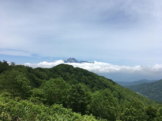
We find a beautiful panorama of Mt. Madarao, Mt. Myoko (妙高山) and Mt. Kenashi (毛無山) from a clearing just past Numaike (沼池) / Nozomiko (希望湖). So we take a snack break (second breakfast!) to enjoy the view and discuss that we should’ve camped there instead. For next time!

After Wakui (涌井), most of the trail is on forest road (林道) with little cover on a hot and sunny day. 31 degrees when I check my phone. We break for lunch and put out damp tents to dry at Tomikura Gap (富倉峠) around noon. Just past Tomikura Gap are sweeping views of Iiyama Valley. Apparently, this is where famed warlord Uesugi Kenshin, daimyo of Echigo province (present day Niigata), set up camp to battle his rival Takeda Shingen who had conquered Shinshu (present day Nagano) during the Sengoku period (16th Century).

Around 2PM, we are hot, sweaty and exceedingly grateful to reach a nice little pentagonal hut perched on the ridge near the top of Kuroiwayama ( 黒岩山) where there is a nice cross breeze. We strip down to sports bras to dry our t-shirts in the cool breeze.
We’d been a bit intimidated by the distance in the morning, but since most of the trail was forest road or old trading routes (graded for horses and ox carts), the trail was pretty flat the whole day and we arrive at our second campsite at Katsuraike about 3:30PM. We take a brief swim in Katsuraike to cool off (too hot and sweaty to care about monsters) and then sunbathed a bit to dry off. The forecast for Wednesday was rain and cloud cover began to come in at dusk. At Genna’s first report of hearing a mosquito, I zip myself into my tent for the night.


Day 3 – Wednesday, June 21
Course: Katsuraike (桂池) → Sekida Gap (関田峠)
Distance: 11.4 km on the Shinetsu Trail, plus 1.5 km to campsite
I wake up to a large tick clinging to the screen door of my tent looking like a kid trying to lick ice cream through a store window. Nope, I think, and flick it off with my finger into the grass somewhere. It’s a rainy morning but luckily there’s an empty rundown old house at the campsite serving as a makeshift shelter. In the shelter, we hang our tents to dry and cook breakfast. We get a late start to the day around 9AM after the rain lets up a bit.

Getting water at Taroshimizu spring (太郎清水)
My rain jacket wets out almost immediately and turns into a sauna suit. The first 3.5km of the trail after Katsuraike is a tough uphill climb to the top of Togari Onsen Ski Resort with two small stream crossings along the way.

When we reach Togari Onsen Ski Resort, we climb onto one of the ski lifts to dry off and cool down.

Togari Onsen Ski Resort
Then there is a bit of a climb up the ski hill. Shortly after we get off the ski slope and back into the trees again, the rain stops. The clouds lift first over Iiyama valley and the wispy clouds hanging over Nozawa Onsen and the Chikuma River (千曲川) were so pretty. Thanks to the rain, we’re able to see frogs and mushrooms, snails and slugs on the trail. So, all in all, I’m actually glad we had to hike in the rain.
The narrow knife ridge up to Mt. Nabekura (鍋倉山) is definitely the highlight of the trail. We could see all the way to Naoetsu (直江津) and the Sea of Japan on one side and all the way up and down the Chikuma river valley on the other, all at once! Though the rain had stopped, it was still extremely windy from the storm and I had to remember to pay attention to my feet and not fall over.

Nagano side

Niigata side
Since the ridge is so narrow and windy, at some point near 1PM we simply squat straight down on the trail and eat a well-deserved lunch. We rest again at the top of Mt. Nabekura and again at Mt. Kurokura (黒倉山), where the sun comes out and we are able to dry our tents and put away our rain jackets.
Yesterday it was 31 degrees but today the temperature was in the low teens. I wore my thin leggings and merino wool long-sleeve hiking shirt (which dried like a champ), but otherwise probably didn’t need to bring these extra clothes
We detoured off the trail to Chayaike (茶屋池) which was worth it because it was a very pretty pond and had a lovingly maintained toilet.

Our campground for the night, Green Pal Kogensou (グリーンパル光原荘) had apparently not opened for the season yet. It was still very windy when we arrived that we spent a lot of time looking for the most sheltered tent site, only to have the wind die down by the time we got our tents set up. We cooked dinner on the deck of the main green building at the campground with a view overlooking the mountains of Joetsu and the Sea of Japan.

Day 3 on the Shinetsu Trail was green tunnel and killer vistas, what I imagined it would be like hiking the ridge between Nagano and Niigata. Day 1 was tromping around Madarao Kogen; Day 2 was mostly road walking; Day 3, we got to the good stuff.
Day 4 – Thursday, June 22
Course: Sekida Gap (関田峠)– Nonomi Gap (野々海峠)
Distance: 18.9 km on Shinetsu Trail, plus 1.5 km from campsite
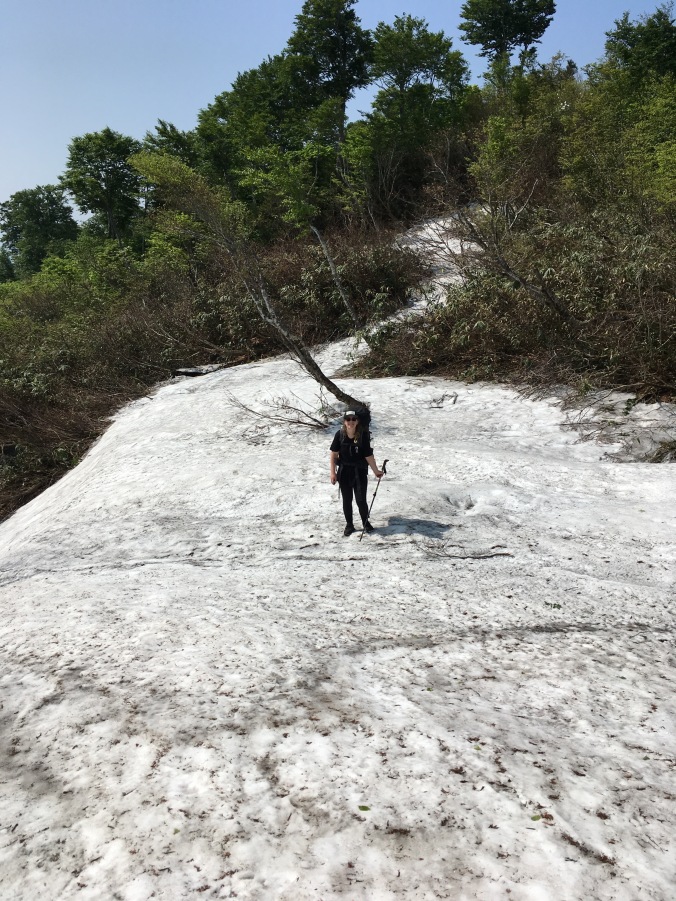
I was thinking while hiking that there would not be much to say about Day 4, except that we started to see snow on the trail: snow patches tucked in shady areas, snowmelt ponds and muddy depressions where there had probably been snow until very recently.
Previous days we noticed that if we came upon a muddy bit, there would be a lot of flies. Well, today was pretty much all muddy, what with yesterday’s rain and the recent snowmelt, so there were a ton of flies.
The trail became challenging but monotonous; a lot of slippery, muddy ups and downs and “limbo trees,” what we decided to call tree branches/trunks crossing the trail at inconvenient height to either duck under or step over. There were great sweeping views of Niigata, but not as dramatic as yesterday. You couldn’t really see the sea because it was quite hazy without yesterday’s rain.

We emerged at Nonomi Gap just as a group of retirees were being loaded onto a minibus. (They were a hiking group from Osaka thru-hiking the Shinetsu Trail in six days, staying two nights at Madarao Kogen and three nights in Togari Onsen.)
The bus driver asked where we were going and we were able to hitch a ride to our campsite 2km down the road at Nonomi pond (野々海池).

Skunk cabbage blooming at Nonomi pond
The campsite looked nice enough. But as we put our tents up, we attracted a swarm of black flies. And then, they started to bite. The taps at the indicated water source were not running (probably turned off to prevent pipes from freezing in the winter), so we had to go down to the lake to get water, while being tailed by a vicious swarm of flies. Genna daringly waded into the pond with a plastic grocery bag to get less scummy water to fill the Sawyer Squeeze bag with and we both had to sacrifice ourselves to some flies to filter 4 liters of water for camp. Teamwork!
Our hardship turned out to be unnecessary, because on the way back I stopped by the toilet and found out the hand-washing tap by the toilet was running. It makes a good story (did I mention Genna almost stepped on a snake, I screamed my death scream and the nice guy working on getting the campsite ready for the season hopped in his k-truck to check if we were okay?), and I guess there had to some Type II fun on our trip.
Flies were still swarming our tents, so we boiled a pot of water, split it in two and literally dove into our tents. There must’ve been around 200 flies swarming the fly of my tent. The sound of the flies flying into the fly of my tent sounded like rain. I killed the 5 that got inside my tent when I dashed in. Then, there was nothing to do but eat and get ready for bed. I was pretty happy I didn’t have to get up and go to the bathroom at any time that night.
Day 5 – Friday, June 23
Course: Nonomi Gap (野々海峠) → Mt. Amamizu (天水山) → Daigonji Kogen Campground (大厳寺高原キャンプ場)
Distance: 6.2 km on the Shinetsu Trail, plus ~5 km to get to the trail and off the trail from our campsites
I wake up to a brilliant symphony of birdsong. And only 8-10 flies still hanging around my tent. I have not left my tent since 6-something yesterday evening and contemplate getting up to go to the toilet. I check if Genna is awake yet and then go back to sleep. I wake up again and get ready for the day by packing up everything except what I need to wash up and make breakfast.
Having confirmed that Genna is up, I work up the courage to exit my tent, go to the toilet, wash my tenugui and brush my teeth. Flies do not follow me, and things are looking good. But, when we start boiling water for breakfast, the swarm reappears and breakfast is another split the hot water and dive for tents affair. After we’ve finished eating our breakfasts, it’s a non-stop dash to take down tents, pack up and leave, barely stopping at the toiler sink to fill up on water. We have to keep moving or the flies will catch up. I think we’re on the road around 7-ish, but I didn’t keep track because our priority was just to beat the flies. We look like Pigpen from the Peanuts comics, being followed by a little cloud of flies.
Up the trail from Nonomi Gap we reach a sunny clearing looking down over Niigata where the trail hooks 90 degrees to the right. We stop to make some coffee and dry our tents. It’s okay for a bit and then we start getting bitten again. We’re just finishing packing up when the group of senior citizen hikers from yesterday appears. As we move on ahead, I overhear their guide explain that our choice of coffee spot is the northernmost point of Nagano Prefecture.

Misaka Gap, final pass before Mt. Amamizu

View of Niigata from Misaka Gap
Then it’s more up and downs through muddy bits and the most significant snowfield we cross on the trail (still pretty small) and before we know it, we’ve reached to top of Mt. Amamizu, the official endpoint of the Shinetsu Trail. It’s only 10AM. We take a few photos, finish our coffee and get moving again before the flies gather too thickly.

Another uphill. “Guess what day it is?” “Leg day!”

Finish! Official endpoint of the Shinetsu Trail.
Down toward Matsunoyama trailhead, we meet an old man picking bamboo shoots with bear bells that sound like pretty wind chimes. In 80km, we’ve walked a bit backwards in the spring season, despite having come down in elevation. At the trailhead, we meet to bus driver that gave us a lift yesterday and chat for a bit about their group and he points us in the right direction for our last campsite at Daigonji Campground.
We decide to road-walk rather than take another trail to the campsite after I ask Genna the rhetorical question, “Have you had enough nature yet?”
We get to the campground just past 11 and the manager is not in yet. One of the guys working there cutting grass can’t believe we’ve walked all the way from Madarao and keeps saying “sugoi desune!” and pulls out some folding chairs for us to sit on. I ask if the restaurant is open. It is. So, instead of waiting for the manager, we go to the restaurant and have the most beautiful and delicious hiyashichuka (cold summer ramen noodles) I have ever seen in all my years of living and traveling in Japan.


We put our hats back on for this photo cuz our hair was so greasy and gross. 😛
We also have two beers apiece which get us nicely buzzed since we haven’t had alcohol since??? Then we check in and ask about taking a bath, but the guesthouse is not open yet, so we can only use the shower in one of the cottages. We get the key to a cottage, which has a nice deck with a breeze. I do some laundry in the shower and hang it on the deck to dry and write the last of my trail journal lying on the deck in my underwear. It’s so nice. The perfect temperature, shade, no flies, breeze; a beautiful day. We chill on the deck of the cottage until we get kicked out of the cottage for the next guests to use the shower.

After the hike, we chilled for the rest of the day and the next at Daigonji Campground doing nothing except laying around eating the rest of our food.

Our view during dinner at Daigonji Campground
Post-hike Reflections / Advice
I was discouraged from doing this hike prior to July 1 by the Shinetsu Trail Club because they hadn’t completed train maintenance until last weekend and there was still a bit of snow and felled trees on the trail. Except for our last camp site, none of the tent sites we used were officially open. It wasn’t a problem because no one else was there and there were toilets and water sources at each camp site. I think the trail would be beautiful in earlier spring green, perhaps from May.
I’m glad I did not wait until July to do the trail because it was already really hot. It’s not high elevation, so it really did not cool down at night either. I only had condensation inside my tent the first night. In terms of warm layers, all I should have packed was a 100 weight fleece. I tried sleeping without my long johns on one night but since I use a quilt, my thighs were sticking uncomfortably to my sleeping pad so I had to put them on.
The prime season for hiking the Shinetsu Trail must be Autumn. There were so many varieties of Japanese maple lining the trail it must be very beautiful for fall colors.

Out of season red leaves. A teaser for fall?
The Shinetsu Trail is still not so well-known among Japanese hikers. It’s refreshingly undeveloped, but well-maintained and adequately marked. Even though there is very little infrastructure on the trail after Togari Onsen, you are never more than a few hours walking to a town if you need to bail or get help. (I also had cell phone coverage the entire time.) It was a great trail to do a beginner long-distance trek. Perhaps because we were hiking before the official start of the season, the only other hikers we saw were the two boys the first day and then the group of ~16 retirees from Osaka that gave us a lift on the end of the fourth day. We did see a few other people during our hike doing forest road maintenance or picking spring mountain vegetables.
Matsunoyama Onsen near the end of the trail is a very cute little hot spring village and I’d probably try to stay there next time because Daigonji was still pretty much the middle of nowhere. Good thing Kiwi Sig Other showed up with a rental car so we could get back to civilization. It’s probably pretty easy to hitchhike down to civilization from the trailhead as the only people around are friendly locals who know about the Shinetsu Trail. The magic onsen water cured the itchiness of all my fly bites. Not bad for one of the Three Famous Medicated Onsen of Japan.
Contact me if you have any questions about hiking the Shinetsu Trail!

Pingback: Shinetsu Trail: What was in my Pack? | Tu Meke Tina
Looks awesome! Tina vs flies an interesting subplot, lol
LikeLike
Hi ! I am going to do this trail in few days ( in 3 days actually !) but I am having troubles deciding what to bring for food. I am a bit lost with japanese food. Can you give me few examples of light, filling , cheap food for trekking in japan ? Thank you =)
Also, its going to rain, so i wanted to know if the little huts at the campsite are open, and if its possible to hang some clothes ? leave my bag for the night etc.
And last question : I might have to stop before the end because maybe I need to go back to civilisation earlier than previous. if I take 3 or 4 days, where do you recommend to stop? I don’t want to stop just before a really nice part of the trail
thank you in advance !
Lucille
LikeLike
Hi! Sorry didn’t see this earlier. Hope you managed to figure everything out and had a good trip!
LikeLike
Hi. A friend an I are thinking of hiking this trail next fall. We are from Australia and would like to use tents. Did you book tent sites prior to your trip and did you have to camp in designated areas or can you camp where you like??
Thanks
Fiona
LikeLike
We hiked outside of the official season so were unable to book the tent sites. You are supposed to book the tent sites at http://www.s-trail.net/english/ which I would recommend because Japan is densely populated and tends to be pretty crowded during peak season (think autumn leaves).
LikeLike