On clear days, you can see Dabajianshan (大霸尖山) from my parents’ apartment perched on the hills southeast of downtown Hsinchu. The distinctive square shape of the peak makes it super easy to recognize. It’s on the 500NT note. Dabajianshan is the holy mountain of the Atayal people and where they believe their ancestors came from. The “ba” in Daba means “dominate”; it’s the same character used in「霸王」or warlord. All reasons I decided to climb it.
Most people climb Dabajianshan in a 3-day hike, staying two nights at Jiujiu (or 99) Hut, which is manned. However, a Chinese language hiking guide I read strongly suggested breaking up the hike into 4 days and tent camping at 3050 High Ground or staying at Zhongba Hut which appealed to me because I like to avoid crowds and had a romantic idea of seeing sunrise from Dabajianshan.
Trail journal below.
Day 1 – Monday, July 17
Dalu Forest Road (大鹿林道) to Madara Creek Trailhead (馬達拉溪登山口) (19.5km)
Dalu Forest Road is an easy walk. It’s a mostly gravel road crossed by many small waterfalls. I actually get to see most of the endemic and endangered birds and butterflies described on the interpretive signs along the trail. Good job with signage and conservation efforts, national park and forest service! The road winds up the side of the mountain and the view on the other side of the valley is not bad. But it does get tedious after about 10km. (And there is no where secluded to pee.)
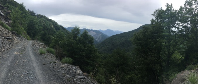
Beginning of Dalu Forest Road

Gwanwu Waterfall – a popular day hike in Guanwu Forest Recreation Area but you can’t tell it’s this high from the bottom of the waterfall.
Dabajianshan used to be a popular two-day climb, but typhoons repeatedly washed out Dalu Forest Road so its been closed to private motor vehicles since 2008 adding an additional 20km each way to the hike. You can see how the road was damaged and how streams/waterfalls just run across the trail in the video below.
I drove up in the morning from my parents house in Hsinchu past Judong (竹東) and Chingchuan (sp? 清泉) (a beautiful hot spring village high in the valley where Zhang Xueliang, the once rival warlord to Chiang Kai-shek who was blamed for losing China to the Communist Party, was once held in house arrest), so by the time I arrive at the trailhead to turn in my permit it’s a few minutes past 11AM, and the ranger lets me though without watching the safety video, because he wants to get off his shift. You’re not suppose to enter the trailhead after 11AM because of the long walk up to 99 Hut (4 hour, 4km hike up from Madara Creek Trailhead), but I’m only camping at Madara Creek. Since I get a late start, I meet only one other hiker going up that day when I’m hiding from the rain in a worker shack at the 15km mark. He has a thick accent and I imagine what exotic location he is from in China. (Later I find out it’s Macau.)
When I finally get up to the campground in front of the abandoned visitors’ center at Madara Creek around 5:45PM, the water is not running at the toilets which is troublesome because there aren’t any good places to do you business around there. (It is apparent people have been using the toilets anyway and they are really gross.) I’m staking in my last couple of tent pegs when two vans pull up filled with workers who will be staying the night. They take over the visitors’ center building, despite a sign posted saying that the foundations of the building are not stable so do not enter.
I was looking forward to relaxing and enjoying my solitude since I have the sole permit reservation for the campground, but now my peace is disturbed by a chainsaw and leaf blower as the workmen build a f-ing bonfire.

They were there to cut the grass along the forest road the next day.
I retreat to the nearby forestry service workers’ hut and manage to have a quiet dinner overlooking the creek. After dark, there are too many bugs in the hut (elevation ~1800 meters), so I have to hastily pitch my tent inside the hut. This was not as relaxing as I hoped!
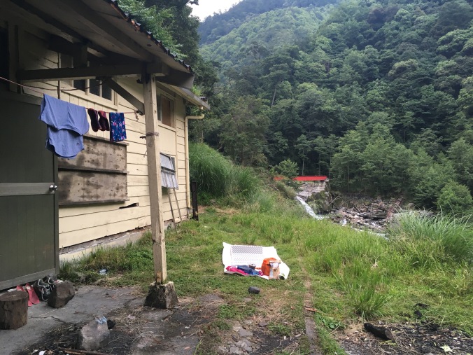
Forestry Service Hut
Day 2 – Tuesday, July 18
Madara River Trailhead to Zhongba Hut (中霸山屋) via Jiujiu Hut (九九山莊) (9.5km), and evening visit to Dabajianshan (4km round trip)
I sleep in longer than I intended because it is so dark inside the workers’ hut and only finish packing when I hear a leaf blower go on. I finally cross the red Madara Creek Bridge and start hiking just before 8AM. This results in me getting hailed on in the afternoon thunderstorm on the way to Zhongba Hut. It’s been classic Taiwan summer weather recently – 午後雷陣雨 – not-a-cloud-in-the-sky mornings followed by afternoon thunderstorms.

Looking back across Madara Creek Bridge towards some hikers coming down from the mountains that morning
Not very far up the trail, I dig my first cathole the first place it looks viable to go off trail. It’s difficult, but I hit a rock and after wedging the rock out, the hole reaches regulation depth. (Review LNT principles here.) Achievement unlocked! I’m back on the trail clipping my potty trowel to my backpack when a hiker coming down passes me. Lucky!
The climb up to Jiujiu or 99 Hut is a slog, except for around the 2.4KM mark where there is old grown cypress forest. I love the smell of hinoki! Apparently there are two kinds: Taiwan Cypress /扁柏/ヒノキ, and Formosan Cypress/ 紅檜/ベニヒ. I thought they were all the same. FYI a lot of the large cypress tori (e.g. at Meiji Jingu) and large hinoki baths in Japan are constructed out of Taiwan hinoki.

Cypress forest
I wander into 99 Hut to checkout the facilities even though I don’t plan on staying there and get ambushed by the caretaker and the cook who make me sit and drink ginger tea and then oolong tea with them. The cook feeds me sausage and eggs left over from breakfast and gives me two tomatoes for the road. The caretaker names all the flowers in the photos I took on Xueshan and shows me photos of Dabajianshan that he’s taken in all conditions. “This year, it snowed April 1 at 99 Hut!” he says as he proudly shows me the photo. He’s incredulous I have only brought my phone for photo taking purposes. I finally extract myself by promising to stop by again on the way down.
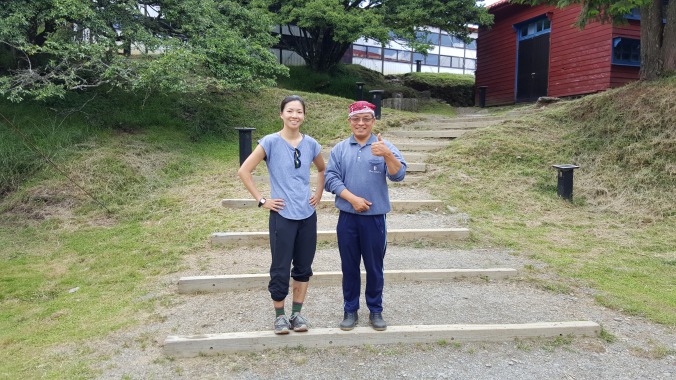
Mr. Chang, the caretaker of 99 Hut, and I
On Daba Trail there are four baiyue: Dabajianshan (3492m), Xiaobajianshan (小霸尖山 3360m), Yizeshan (伊澤山3297m), and Jialishan (加利山3112m). It is hailing pea-sized pellets at the time I reach the junction for Jiali Shan. I see two people turn off the main trail to climb Jiali despite the crappy weather, but I skip Jiali and Yize and head straight along the increasingly muddy trail to Zhongba Hut for shelter. I’m not that crazy about peak-bagging baiyue; I’d rather get dry. It’s a good thing that after the junction for Jialishan at 3050 meters, the trail is never very steep.
At 3:20 in the afternoon, I’m resting on the deck of the very cozy Zhongba Hut. Arrived, swept out the hut, and had a pee before it started raining again. Great facilities here! Cathole digging equipment and rainwater collection tank with water coming out of a tap just out back. I lost my trash bag out of the side pocket of my backpack, probably when I set my pack down to dig out my rain jacket. I hope I find it on the way back down or I’ll feel really bad.

Zhongba Hut
The clouds part above Zhongba Hut around 5:50PM, so I decide to go to Dabajianshan and see what I can see.
Dabajianshan is hiding mysteriously in the mist when I approach. I bow and say a little prayer of thankfulness and hope for good weather and safety and then cross to the metal rails toward the traverse under the Daba peak to Xiaoba. There’s a sign attached by a chain to the metal railing, and I’m taking a selfie with the sign and white where Daba is supposed to be behind me, when suddenly the clouds part and I see Daba clearly on my phone screen. Of course, I immediately turn around and shout “Wow! Wow! Wow!” out loud to nobody.


If ever you arrived at the top of a mountain and were sure it was a god, it would be Dabajianshan. You can’t step on the top and conquer him (no longer permitted by law because it’s dangerous, and really you shouldn’t out of deference to aboriginal beliefs), but you can sit at his feet and look out onto the wondrous view he has. I don’t stay long, because I want to be back at the hut to cook dinner before dark, and I want to get an early night so I can be back up at Daba for sunrise.

No, this is not a stock photo. I took it with my very own wee little iPhone.
Day 3 – Wednesday, July 19
Zhongba Hut to Dabajianshan and Xiaobajianshan and back (5km?), then down to 99 Hut (9.5km)
Zhongba Hut is snug and quiet, no bugs, no scurrying or other animal sounds. The only sound is the occasional commercial jet flying overhead. When I wake up at 4:20, I go outside and can still see many starts though the horizon is getting reddish. I make a coffee, bottle it up and go to have breakfast with Dabajianshan. On the way, I can see the twinking of a city’s lights in smog far down below.
I wondered if anyone would make a night climb from 99 Hut to see the sunrise, but turns out it’s just me. It’s an amazing experience to share the sunrise with Daba; one tiny human and a great mountain god.

Sunrise at Dabajianshan
Indeed, as the 99 Hut caretaker had told me, at sunrise, Daba is first red (5:09AM) and then turns golden yellow (5:13AM). After sunrise, I cross under the square Daba peak formation and head for Xiaoba. The ridge between Daba and Xiaoba offers great views of Xueshan and the Holy Ridge, but I can’t take any good pictures because they are eastward in the direction of the rising sun.


I get lost at the bottom of Xiaoba. On the way up yesterday, 3 separate hikers had warned me that the ropes on Xiaoba were damaged, not reliable and that they had forgone getting to the top. Unable to find the ropes, I end up behind the formation on the east side, then come back around and make an attempt at climbing up the north face, but then decide I don’t really want to get dead. I’m about to give up when I find a marker and finally locate the ropes. There are plenty of good footholds and handholds along that route that the tiny, tiny bit of indoor bouldering experience I have is enough to make me feel comfortable enough to climb up and down without relying on ropes.

Panorama from top of Xiaobajianshan (Xueshan Main Peak in the middle of the photo in the mountain range in the distance)

I climbed this rockpile by myself and didn’t die.

Ridge between Dabajianshan and Xiaobajianshan
When I get back to the bottom of Daba, I meet four recent college grads, two girls and two guys. I take a few photos from them and they take a couple for me. One of the guys points out Turtle Island, the distinct island off the coast of Yilan, in the distance, indicating that the lights I saw below before sunrise were probably Taipei. It’s about 8 AM, which means I got to spend 3 hours hanging out with Daba and Xiaoba all by myself.

When I get back to Zhongba Hut, there is a guy inside passed out in his sleeping bag. I try to gather up my things quietly and prepare to pack-up and cook my breakfast on the deck outside the hut. After a bit, he gets up and comes outside for a smoke. “Where did you come from?” I ask, since no one was there when I left at almost 5AM. Turns out he’s a porter carrying gear and lunch (!) for the group of hikers I ran into on top of Zhongba lookout (中霸坪) on the way back here. He lives in Chingchuan. The group he’s with got up in the wee hours to see sunrise at 3050 High Ground near the junction for Jialishan and they will be having lunch at Zhongba Hut. I offer him a sachima (a type of Chinese pastry I packed as breakfast food). He wanders off the pee and then goes back to bed. [Aside: Not to judge… Okay totally judging… but if you can’t carry your own lunch on a day hike (since they stay two nights in a row at 99 Hut)… Catheter and bedpan, much?]
I climb Yizeshan and Jialishan and take the obigatory peak photos on the way back down to 99 Hut. By the time I get to the top of Jialishan the cumulonimbus have piled up threateningly.

Yizeshan – laminated sheet someone left up there

Jialishan – Notice cloud difference from previous photo
I manage to make it to 99 Hut at 2PM just before it really starts pouring and take up the caretaker’s offer to stay there (instead of back down at Madara Creek Trailhead — being a government facility, he does charge me the requisite 200NT) and the cook’s offer of hot dinner (complimentary). When the rain lets up I go take a nap until dinnertime.

After dinner, I joined other hut stayers to watch the sunset, but the clouds didn’t quite clear in time, so we were treated to a cloud light show instead.
Day 4: Thursday, July 20
99 Hut to the beginning of Dalu Forest Road (23km)

Sunrise at 99 Hut
I tried to decline hot breakfast the night before but am woken up at 4:30AM by the cook anyway. No matter, I wanted to get moving early anyway in attempt to finally beat the afternoon thunderstorms one of these days. I’m back through the old growth forest at 7AM and back across the red bridge at Madara Creek Trailhead at 8:40AM. Not much to say about the day except I leap-frog with the porter I met at Zhongba Hut all day, chatting occasionally, and cross paths with a group of 7-8 other young porters from the same company bringing 200kg of fresh food up to 99 Hut in anticipation of the weekend. The forest road is monotonous since I’ve seen it before and I end up listening to Mindy Kaling’s Why Not Me? on Audible. (She had something really insightful to say about confidence and entitlement at the end of the book. Really!) Cumulonimbus are looming again by 1:30PM but I manage to finish the trail just before 2PM and before any rain!

Finish!

Convenience store dog at the Hi-Life I stopped at in Judong to get coffee on the way home. It was, of course, super hot back at lower elevation and this dog was enjoying a nap in the AC. Must be tough being a Husky in Taiwan. #itsadogslife

That looks truly amazing! I’m really looking forward to doing some multi-day walking.
LikeLike
Awesome pictures!
LikeLike
the climbing rockpile shot was awesome!
LikeLike